
Technologies are constantly evolving, and mobile scanning and reality capture are no different. While changes to hardware are obvious (compact, lightweight scanners that are handheld , wearable , or flown are now the norm), software that enhances the user experience might not be as apparent.
While less obvious, this software is helping users work smarter, not harder. For instance, by pairing the Leica BLK2GO PULSE handheld first-person laser scanner with the Leica BLK Live app , users enhance their overall experience in a multitude of ways.
In this article, we’ll highlight the advantages of Leica Geosystems’ hardware and software individually, as well as how they work together side by side to streamline the data collection and transformation processes, making it easier than ever to capture and share data from anywhere, at any time.

Introducing BLK2GO PULSE: It’s as simple as point and go
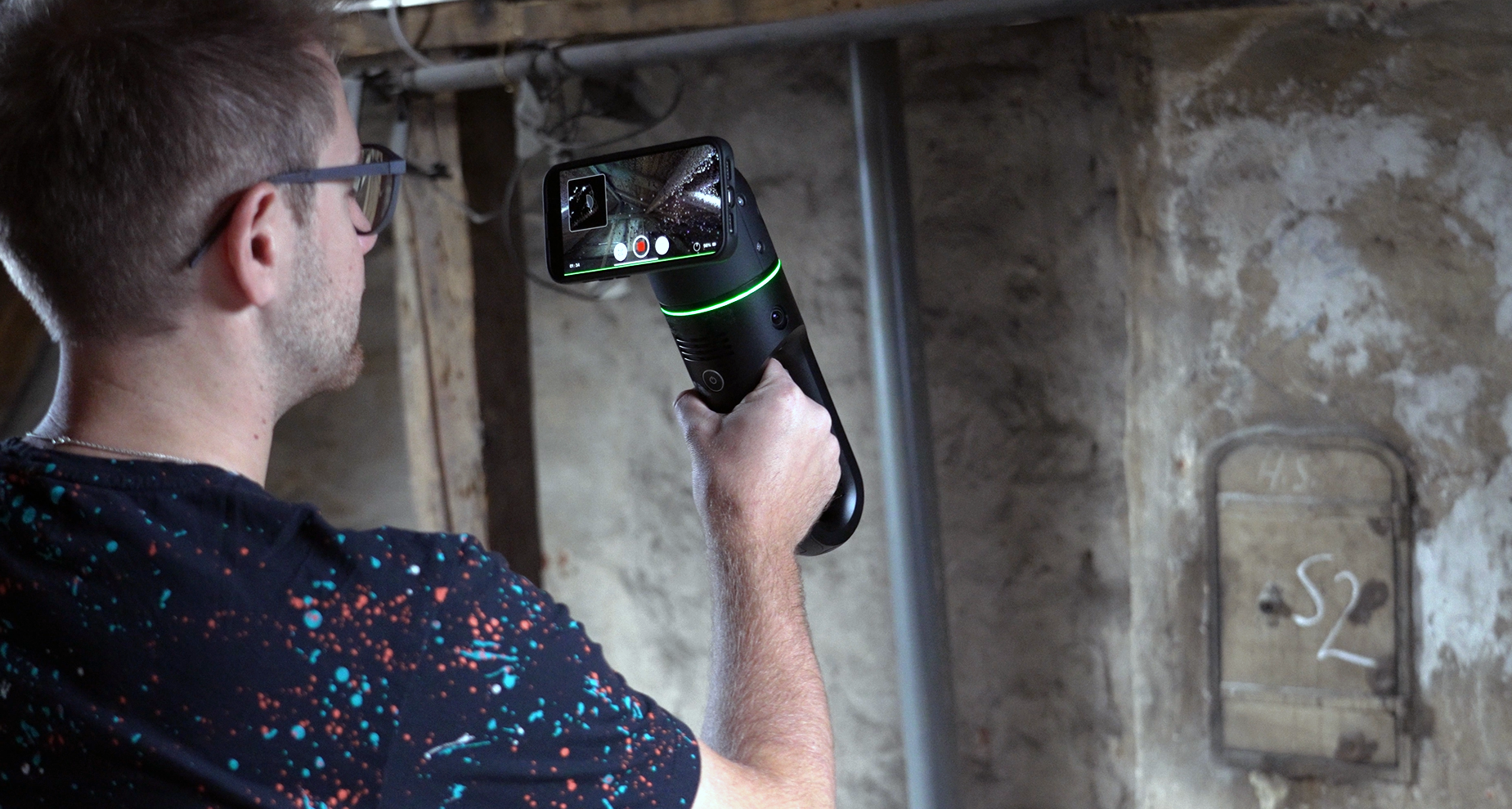
A state-of-the-art piece of technology, the BLK2GO PULSE is the world’s first dual Time-of-Flight (ToF) laser scanner. It’s a lightweight, first-person handheld scanner that enables the user to see what the scanner sees when paired with the BLK Live app.
It’s also user-friendly, meaning anyone can use it to capture data - it’s as easy as taking a video on your smartphone. This enables users to intuitively scan and instantly take in the scene in front of them, capturing every detail in colour, just like reality.
A key feature that is unique to BLK2GO PULSE is PULSE technology, which is the result of combining advanced dual ToF LiDAR sensors and GrandSLAM technology. This enables the scanner sensors to colourise the point cloud data in real-time.
For those working in the field, this means they can instantly access and review colourised 3D data without needing to wait to process it in the office or cloud, or later discovering they missed data. It also has a high-resolution camera and three panoramic cameras, making it easy to capture panoramic images and high-res photos positioned in the right place along the path of the scan.

See what your scanner sees: Introducing the BLK Live app
The BLK Live app and interface have been tailored to maximise the user experience by making it easily accessible and easy to use. The app is completely free and compatible with both iOS and Android handheld devices. Once the app has been downloaded, it can easily be paired with Leica Geosystems’ devices.
Once the app is set to the user’s specification, it’s easy to preview and capture data. The app also enables them to rotate and zoom the panoramic images on the go, or they can monitor the progress of the scan and see the scan data as it is being collected.
It is easy to complete general health checks for the scanner with the app. For instance, checking the status of the battery, including how much time there is remaining until it requires charging, how much free space there is on the hard drive, and the sensor’s internal temperature.
Combining BLK2GO PULSE and the BLK Live app for a truly mobile experience:
When combining BLK2GO PULSE and the BLK Live app, users get the ultimate first-person viewpoint, enabling them to quickly scan indoor spaces, as they see everything the scanner sees while also receiving guidance to ensure optimal scanning.
This helps to make the process more intuitive, which is helpful for first-time users and those who are more experienced alike. While using the app, it’s easy to view the captured point cloud, visualise the area with a 2D top-down view, and 3D view of the entire data.
This is useful when assessing if there is any data missing while still in the field. The streamlined approach to scanning makes it easier than ever to capture, review, and share data in real-time from anywhere, at any time.
In addition, because of the combination of advanced technology behind BLK2GO PULSE, users can capture colourised point clouds on the go. This enables them to move through project sites quickly. While this means they’re saving time, it also enables them to gain confidence, as they can see the points captured, ensuring no data is missed.
There are several options for exporting the data captured. The first is the E57 data export, which easily converts the data into point cloud file format. The alternative is to export via Reality Cloud Studio , powered by HxDR, which stores and automatically processes data.
The combination of BLK2GO PULSE and BLK Live app is ideal for indoor use – all users have to do is point and walk. The experience offered by BLK2GO PULSE makes it ideal for industries and projects where stunning, colourised 3D data is needed fast and efficiently, right there in the field. For example, architecture, real estate, facility management, and building construction.
Using both the Leica BLK2GO PULSE handheld scanner and the BLK Live app streamlines the entire scanning process, offering real-time colourised point cloud data, intuitive operation, and instant data review capabilities. Users can now capture, visualise, and share high-quality 3D data with ease and efficiency.
Download the free BLK Live app from the App Store or Google Play today. The BLK2GO PULSE is also compatible with our powerful Leica Cyclone FIELD 360 application .

Jan Gabka
Product Engineer
Reality Capture Division