
How the Leica BLK2GO turned everything I’d learned so far about scanning on its head.
At this point in my scanning journey, I’d spent a lot of time with scanners on tripods — what are known as “terrestrial laser scanners” — particularly the Leica BLK360 G1 and the new BLK360. This meant learning the ins and outs specific to those units, knowing that you are going to spend a certain number of minutes moving the unit from spot to spot, remembering to keep yourself out of the scan image, and trying to reduce the incidences where objects or people move into the frame of your scan. It meant aligning scans in the field at specific points to help pre-register them before final registration in the office. It also meant conducting battery management to ensure the scanners didn’t run out of power in the middle of a scan.
In short, it was great learning. But it didn’t fully prepare me for the BLK2GO.
Luckily, I mean that in a good way.
It might not be fair to say the BLK2GO has no learning curve, but whatever it has, it’s as shallow as possible. Of all the scanners I’ve used so far and scans I’ve taken, it’s this lightweight, powerful handheld mobile scanner that I’d feel most confident I could get the average person running and using correctly in less than 20 minutes. And thanks to its BLK app, if I wanted to show someone just how cool laser scanning was, this is precisely where I’d start.
But first, let’s back it up and talk a little about what the BLK2GO is and how it differs from its terrestrial brethren.
It’s SLAMmin’
Like a terrestrial 3D laser scanner, the BLK2GO uses a combination of LiDAR and cameras to map a space and color the resulting point cloud. Unlike those scanners, where you take a series of static scans and pre-align them together based on common points, this scanner doesn’t have discrete setups. It’s continuously scanning while you walk, which means it also has to continuously track where it — and its data — are in relation to everything else.
To do that, the sensor uses a combination of Simultaneous Localization and Mapping (SLAM) technologies: LiDAR SLAM, which uses laser pulse feedback to identify the geometry of an environment; visual SLAM, which uses the onboard cameras to track similarities from image to image; and an inertial measurement unit (IMU) that tracks motion, rotation, and speed. Put it all together, and you get the BLK2GO’s “GrandSLAM” tech (clearly, we have enthusiastic sports fans on the branding team).
How those things work so well together is beyond my technical ken, but the important thing is that it works well enough that you’ll seldom have to question it.
In the field
 Until now, I’ve done solely setup-based scanning (I almost said “tripod,” but one of the cool things about the Leica BLK360 G1 and the new BLK360 is that it can scan from any stable surface). So, firing up this handheld scanner and going straight to work was a revelation. With the BLK Live app in hand, I could see a visual representation of the subsampled points start to populate in either 2D or 3D, making it obvious how much coverage I was getting at a given moment. And any time I felt like I wanted a little more detail, I stopped and waited for the scanner to fill in with greater density. The real-time feedback was a game changer and its operation — minding to keep the scanner in front of me to keep myself out of the scan data — was wholly intuitive.
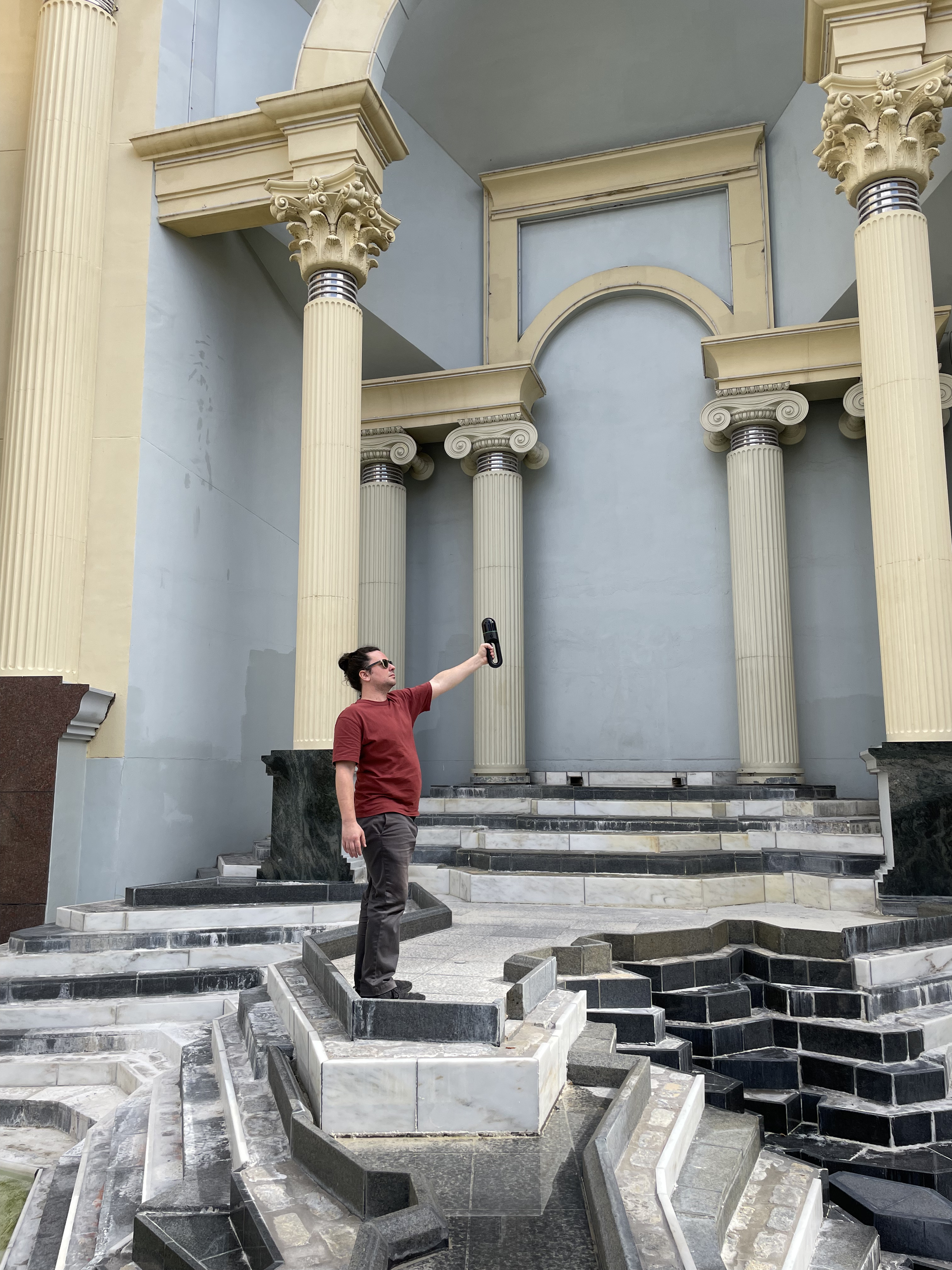
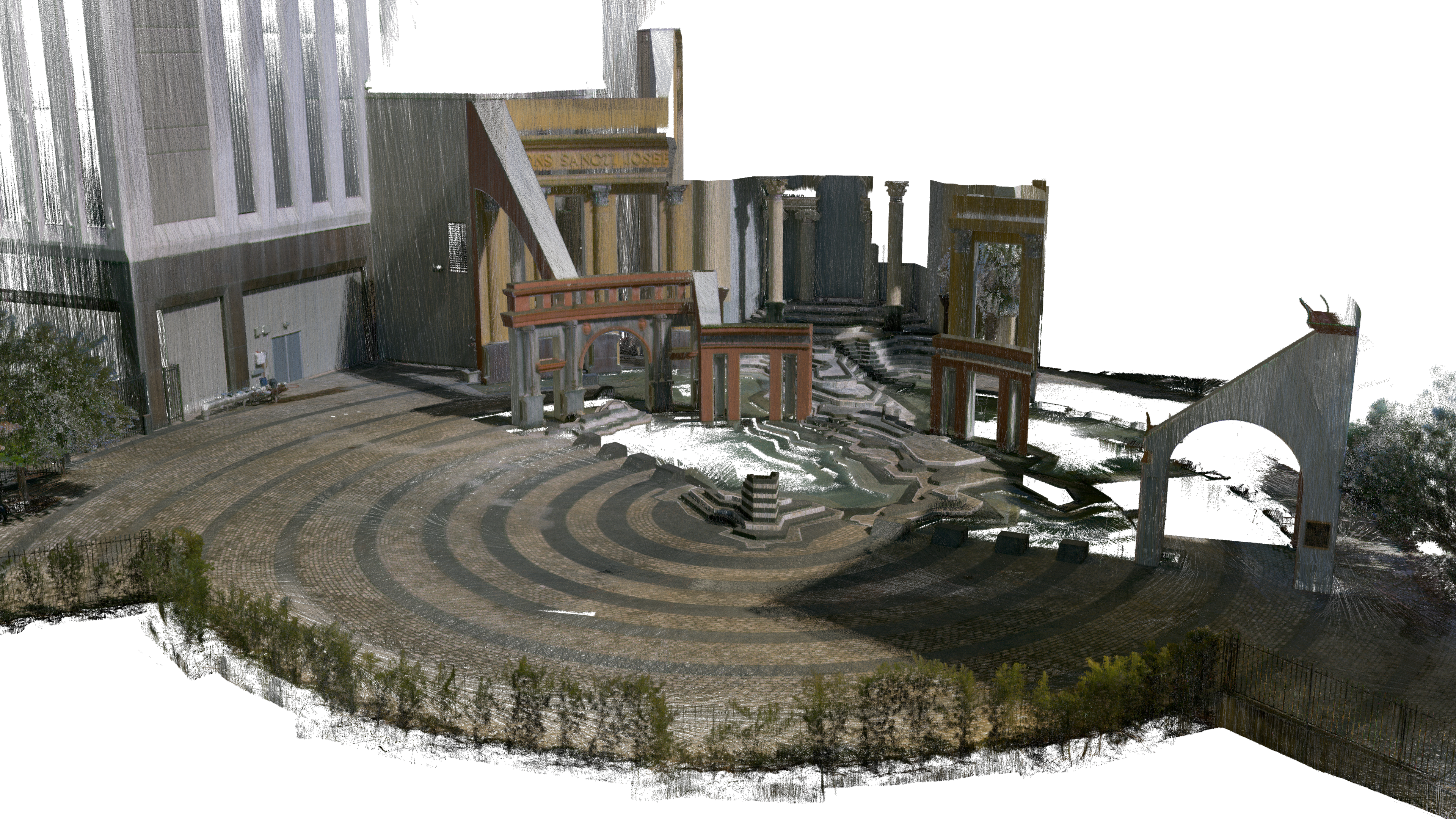
The spot I chose to scan was the Piazza d’Italia here in New Orleans, a truly wild piece of post-modern Italianate architecture nestled between office high rises, built in the 1970s to celebrate the long legacy of Italian immigration and Italian-American culture in New Orleans. It also features complex geometric shapes, from sharp corners and rounded arches to terraced steps and tapered columns.
The BLK2GO handled these with aplomb, capturing even more of the space than I could see via the app, and it was a dream for creating a point cloud with no scan shadows. With a terrestrial scanner, I had to be meticulous to eliminate shadows (where an individual setup can’t “see,” such as behind an object like a lamp or desk) from setup to setup, which was rarely perfect. With the handheld scanner, I could simply walk around objects, ensuring I got the whole picture.
In less than 20 minutes, I’d gotten a rich, detailed point cloud of the entire Piazza.
Differences in data, differences in data processing
Scanning was a breeze, but it’s worth mentioning that there are differences in the data you get from the BLK2GO compared to the other scanners I’ve tried, both visually and functionally. For one thing, the data is less precise, being accurate at plus or minus 10mm compared to 4mm for the new Leica BLK360. And because you’re not creating static setups, that variance can get larger if you’re not moving to a spot to get detailed coverage.
But one of the pleasant aspects of the BLK2GO is not necessarily having to align scans. With the handheld scanner, you go on a “walk,” and all your data — say from my 20-minute scan of the Piazza that totaled 128 million points — there was no aligning to do, just a complete picture from top to bottom. This would change if you combined multiple walks, but it was still a nice feature.
Of course, it was still handy to go back home and clean my data in Leica Cyclone REGISTER 360 PLUS to eliminate undesired points, but I didn’t have to do that. Instead, I was able to upload my scan to Reality Cloud Studio, powered by HxDR, where it both automatically processed and colorized the point cloud and automatically meshed the data (and it’s a pretty great-looking mesh too). The end-to-end simplicity was something to behold.
Final thoughts
Lightweight, portable, with great battery life, and adept at scanning when you need to move quickly within a space, the experience of using the BLK2GO is so pleasurable it’s easy to recommend. Furthermore, I got excited about the possibilities of merging data between different devices. What if I could use my BLK360 to get more high-detailed scans and then bring the BLK2GO in to get the nooks and crannies it couldn’t touch? That’s a match made in modeling heaven.
Disclaimer: This article features the Leica BLK360 G1. Explore the expanded capabilities of the latest BLK360 model here.
![]()


