I’m excited about innovative technology. But taken on it’s own, the benefit is often limited.
What always caught my attention was the ability to combine technology to create workable solutions to help our clients do their jobs more efficiently.
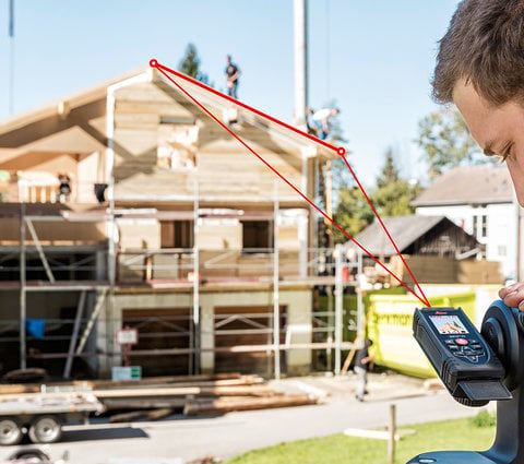
The Leica DISTO S910 has been on the market for over a year now and it still brings me excitement. This device enables you to capture accurate, three-dimensional data from a single location. A task, which could be done in the past exclusively by surveying professionals!
But where are these measurements located? Think about adding measurements to a utility network where the data must be integrated into existing plans.
The combination of the DISTO S910 with a Leica Zeno 20 solves this issue by adding accurate GPS positions. The Zeno 20 is a GPS handheld device for easy asset data collection. It can measure the location of the DISTO with up to cm level accuracy and therefore references all results to the exact location on earth. The output can be directly merged with existing plans within GIS or CAD systems, or just viewed at the correct location in Google Earth. For me as a certified surveyor, this is essential.
It also allows Zeno 20 users to finish their jobs where GPS has its limitations. This includes things such as inaccessible objects or points close to obstructions like tall buildings or under bridges.
We call this gamtec – the combination of GPS with angular and distance measurement technology. A benefit for both workflows!
What is your measurement challenge that could be solved with this powerful combination?
I would be glad if you would share it with us!
Tobias Heller
Product Manager for Leica DISTO