 RTC
RTC
 BLK360
 BLK360 SE
 BLK2GO
 BLK ARC
 BLK2FLY
 BLK3D
BLK3D
 Accessories

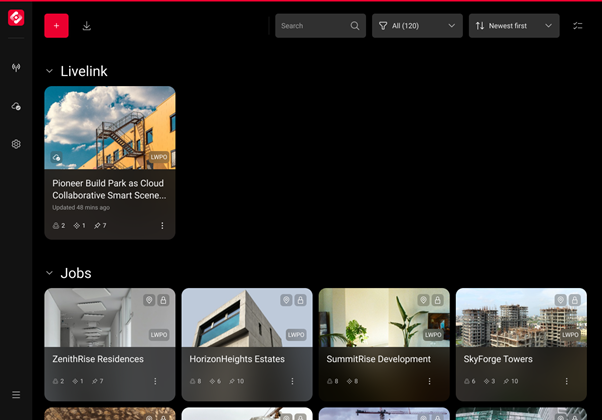
1. Summary
Livelink introduces a new standard with cloud-enabled collaboration for a connected terrestrial laser scanning workflow. Built as part of the new Leica RTC laser scanner series, it establishes a real‑time connection between field and office-based users, enabling project teams to capture, connect and collaborate throughout the entire project lifecycle. For multi-person field crews, this means preview data and capture progress are synchronised between Leica Cyclone FIELD 360 instances/users, ensuring everyone has a shared view avoiding duplicated or missed capture. Livelink provides field and office operators with immediate access to scan data, allowing them to confirm completeness before leaving a project site. Shared project scenes and synchronized scan data streamlines collaboration, delivering faster and more accurate results across all scanning projects. Livelink provides office‑based operators with quality control and quality assurance in complete data, enabling prompt decisions and reducing the need for costly site revisits.
Livelink capability builds on Hexagon’s vision for a connected software ecosystem by unifying data, devices, and people within a cloud‑enabled workflow. With synchronised project scenes, shared visualisation, multi‑operator connectivity and collaboration, and integrated field-to-office communication, Livelink enhances productivity and quality in 3D reality capture workflows.
2. Introduction
Traditional terrestrial laser scanning workflows have conventionally operated with fragmented data flows, sequential processes, and the need for on-site personnel to make point cloud registration and data coverage decisions with incomplete on-hand information.
Teams often work independently, with each laser scanner’s results merged after returning to the office, often leading to incomplete data coverage, requiring costly site revisits or duplicated effort resulting in more time on site than necessary.
With increasing market pressure, rising project demands, and skill shortages, organisations require faster workflows, seamless collaboration, and robust quality control methods. These challenges are consistent across surveying, architecture and construction, plant, infrastructure, and public‑safety environments.
Livelink directly addresses these challenges by enabling real‑time interconnectivity between the field and office operators. Through cloud-synchronised scenes, connected laser scanners, and integrated project coordination, Livelink transforms the traditional terrestrial laser scanning workflow into a collaborative, continuous, and verifiable process.
3. Livelink overview
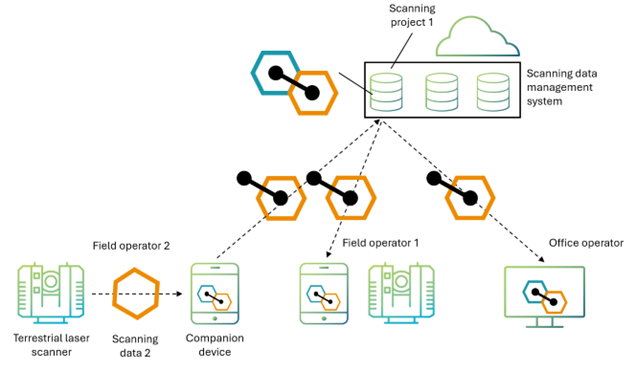
Livelink integrates three core components into a unified ecosystem:
- Leica RTC300, RTC500 and RTC700 laser scanners
- Leica Cyclone FIELD 360
- Hexagon GeoCloud
3.1. Leica RTC300, RTC500 and RTC700 laser scanners
The Leica RTC laser scanners deliver higher accuracy, improved performance, and enhanced robustness while maintaining the portability and simplicity of previous models. Importantly, each laser scanner that’s connected to the Cyclone FIELD 360 companion app can activate a Livelink scene within Hexagon GeoCloud and participate in a cloud collaboration project.
3.2. Leica Cyclone FIELD 360
Leica Cyclone FIELD 360 mobile device app functions as the in-field interface, providing live scan data visualisation, setup verification, tagging, and data enhancement. With Livelink activated within Cyclone FIELD 360, it automatically synchronises project data to the cloud, enabling real-time collaboration.
3.3. Hexagon GeoCloud
Hexagon’s GeoCloud application provides:
- Storage and management of shared scenes and project data
- Multi-user access control
- Capabilities to post-process data for final deliverables
Together, these powerful components create a system where scan data captured in the field is instantly available to remote team members, enabling informed decision-making across the project lifecycle.
4. Livelink core capabilities
4.1. Real-time field-to-office connectivity
Livelink bridges the gap between field operations and office expertise. Data captured onsite is automatically synchronised, allowing office-based specialists to validate setups, provide guidance, and initiate deliverable creation simultaneously to data capture.
4.2. Multi-operator and multi-scanner collaboration
Multiple field operators or multiple laser scanners within a single project team can work in parallel within the same synchronised cloud-enabled Livelink scene. Livelink ensures consistent registration context, eliminates redundant scanning, and safeguards completeness.
4.3. Shared cloud scene synchronisation
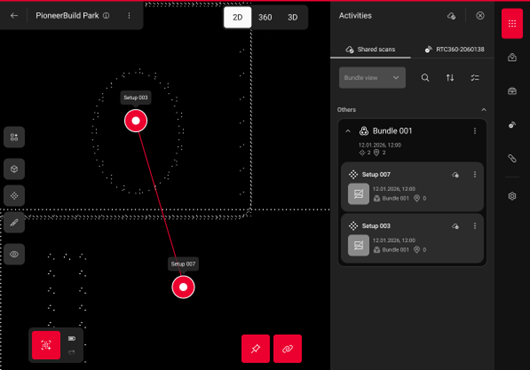
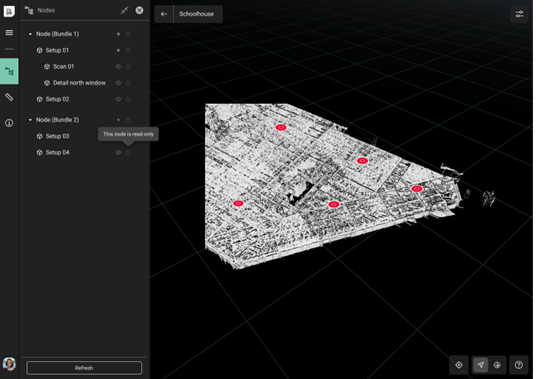
Once connected by a Livelink scene, multiple Cyclone FIELD 360 users can actively contribute to a shared collaborative cloud scene. Every laser scanner is operated by a user who collects data, adds contextual information to enrich the scanning data, and performs the necessary registration steps. Livelink then keeps all data, positions, metadata, GeoTags and related information synchronised across the entire team, so everyone works from a unified and up-to-date project view.
4.4 Guidance & verification
Livelink significantly shortens data flow cycles to bring data to work earlier:
- Real-time scanning progress monitoring
- Coverage and gap detection
- Avoidance of costly site revisits
- Avoidance of uninformed, duplicated capture effort
4.5. Data management
Data is safely stored in the cloud and accessible from everywhere, ensuring fast and lean exchange of the deliverables created in the field. This allows scalable workflows suited for organisations with diverse fleet sizes and varying project demands.
4.6. Data enrichment
Using Cyclone FIELD 360, operators can enrich project data directly on site, with all contextual information instantly shared across the team. Beyond tagging, the software supports a fully integrated surveying workflow, allowing users to capture geo‑referenced measurements and verify control points within the same environment. With Livelink, all results are synchronised and traceable, ensuring reality capture data and surveying deliverables remain aligned throughout the entire project lifecycle.
5. High-level workflow
5.1. Capture
Operators begin scanning with the RTC laser scanners. Visual and inertial data supports fast, reliable setup verification, especially when combined with Cyclone FIELD 360.
5.2. Connect
Cyclone FIELD 360 synchronises captured data and metadata to the shared Livelink scene in the cloud.
5.3. Collaborate
Local and remote team members can interactively collaborate, gaining immediate insight into project progress and completeness:
- Create projects and manage collaborators
- Verify coverage
- Add contextual information and notes
- Begin office-side deliverable generation
This workflow shortens the path from data acquisition to final deliverable and reduces time spent on data import, registration, and cross-team communication.
5.4. Workflow
Livelink is built into the Cyclone FIELD 360 app and integrated into the laser scanning workflow. No separate setup or parallel process is required.
Step 1: Create a Livelink scene
Within Cyclone FIELD 360, the user creates or selects a project in Hexagon GeoCloud and adds project members as needed, then creates a Livelink scene within the project as an enabler for cloud collaboration. The Livelink scene acts as the shared workspace where every collaborator’s scanning data, metadata, and annotations are synchronised and managed centrally.
Step 2: Connect the laser scanner and Cyclone FIELD 360
The laser scanner is paired with the field application. As soon as the project is active, captured scan data and related metadata become eligible for synchronisation into the shared Livelink scene.
Step 3: Start scanning and work as usual
The operator begins scanning as usual. Each scan contributes to the Livelink scene, allowing progress to be tracked across devices and operators. No change in scanning behaviour is required.
Step 4: Automatic synchronisation
As data is captured, preview data representations and metadata are synchronised to the cloud. This enables real-time visibility of project progress without waiting for full data transfers.
Step 5: Collaborate in real time
Other users assigned to the project - either in the field or in the office - can access the same Livelink scene to:
- Monitor coverage and completeness
- Review scan positions
- Add annotations
- Support decision-making during acquisition
Step 6 – Continue or complete the project
Laser scanning continues until the shared Livelink view confirms that coverage and quality objectives are met. This reduces the risk of missing data and avoids unnecessary site revisits, while optimising capture efforts. Once completed, the content of the Livelink scene can be exported as *.FAFx file format and imported into Cyclone REGISTER 360 PLUS for further post processing. Or sharing a link via GeoCloud to invite other contributors or viewers to the project.
Key principle
Once initiated, Livelink runs continuously in the background. The user focuses on the data capture process, while the system ensures connectivity, synchronisation, and collaboration across the entire project lifecycle.
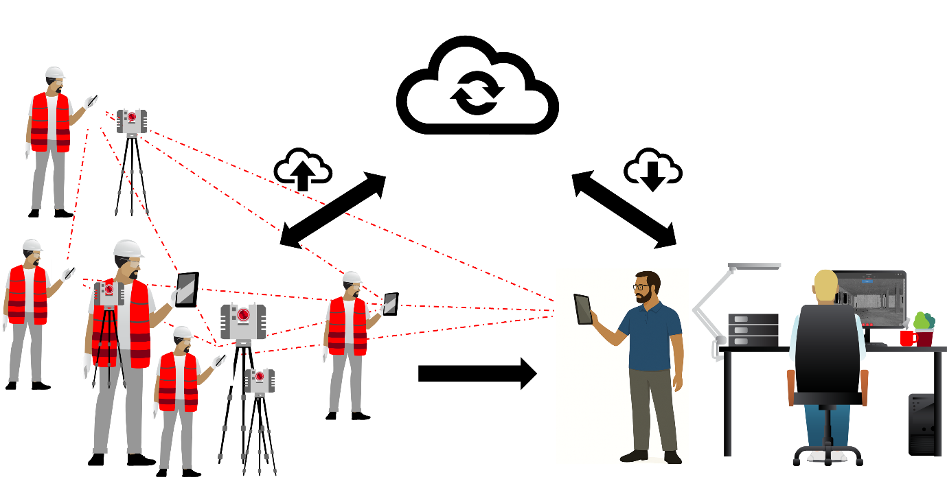
Livelink technical workflow visualisation.
Livelink user workflow visualisation.
6. Conclusion
Livelink represents a significant shift in how 3D laser scanning projects are executed. By enabling real-time field–office integration, multi-operator collaboration, and continuous cloud synchronisation, Livelink shortens project cycles, increases accuracy, reduces risk, and enhances team coordination.
Built on Hexagon’s strong foundation in reality capture and cloud technologies, Livelink sets a new benchmark for productivity and collaboration in terrestrial laser scanning.
Authors:
Chiara Francolini, Product Manager Reality Capture Field Software
Pascal Brunner, Project Manager Reality Capture Software


