
Robot vacuum cleaners and smart thermostats have become commonplace. Autopiloting cars and trucks are just around the corner. Yet entire autonomous systems, using real-time data and machine learning, make important decisions without human intervention, which boosts productivity, unleashes business opportunities and builds a better-connected world.
The autonomous future isn’t simply coming — it’s already arrived.
The Leica BLK Autonomy portfolio enables and drives autonomy. Our latest reality capture devices focus on automating complex, resource-intensive processes and increasing worker safety, freeing humans to do what humans do best: plan, create, and innovate.
“We want these sensors to be as easy to use as possible,” says Pascal Strupler, Business Director of Autonomous Reality Capture at Hexagon Geosystems. “And we want to get to the point where autonomy is not just helping the user get a perfect scan but running independently of the user. Once you don't need the user anymore to scan, you can scale up reality capture in a way you couldn’t before.”
What does that mean? In this blog, we’ll explore the flagship BLK Autonomy sensors: the Leica BLK2GO, our handheld imaging laser scanner, the Leica BLK ARC, our Spot-mounted robotic carrier, and the Leica BLK2FLY our flying imaging laser scanner. And we’ll explore how the captured data is put to work in Hexagon's HxDR platform and helps realize our goal of creating intelligent, autonomous workflows and dynamic digital twins that we call Smart Digital Reality.
Let’s jump in.
The Leica BLK2GO: Handheld mobile mapping

The Leica BLK2GO, our first “autonomous” scanner, still relies on a human being to perform reality capture. However, a combination of machine learning and precision sensors removes the need for repeated setups and automates the registration process through mobile mapping.
Users hold the BLK2GO up while they move, capturing 420,000 data points per second. The handheld imaging laser scanner uses a combination of LiDAR SLAM, Visual SLAM, and an inertial measurement unit (IMU) to deliver extraordinary handheld mobile mapping performance that creates a practical digital twin of a space.
Scan and walk. Walk and scan. Simply put, the BLK2GO is the fastest and easiest way to scan a large building, structure or environment. No surveying experience required.
“The BLK2GO is ideal for things like Scan versus Building Information Modeling (BIM), where you want to see the differences between what was planned and what was actually built,” Strupler says. “You want to walk through that building fast.”
That means sacrificing some detail for speed, but it’s a worthy trade-off.
“The quality needs to be there, but it doesn't need to be as accurate as, for example, the BLK360,” he said. “It's more about, ‘Was this pipe placed in the right place? Was it placed at all?’ The key with the BLK2GO is efficiency.”
Full autonomy made possible — the Leica BLK ARC
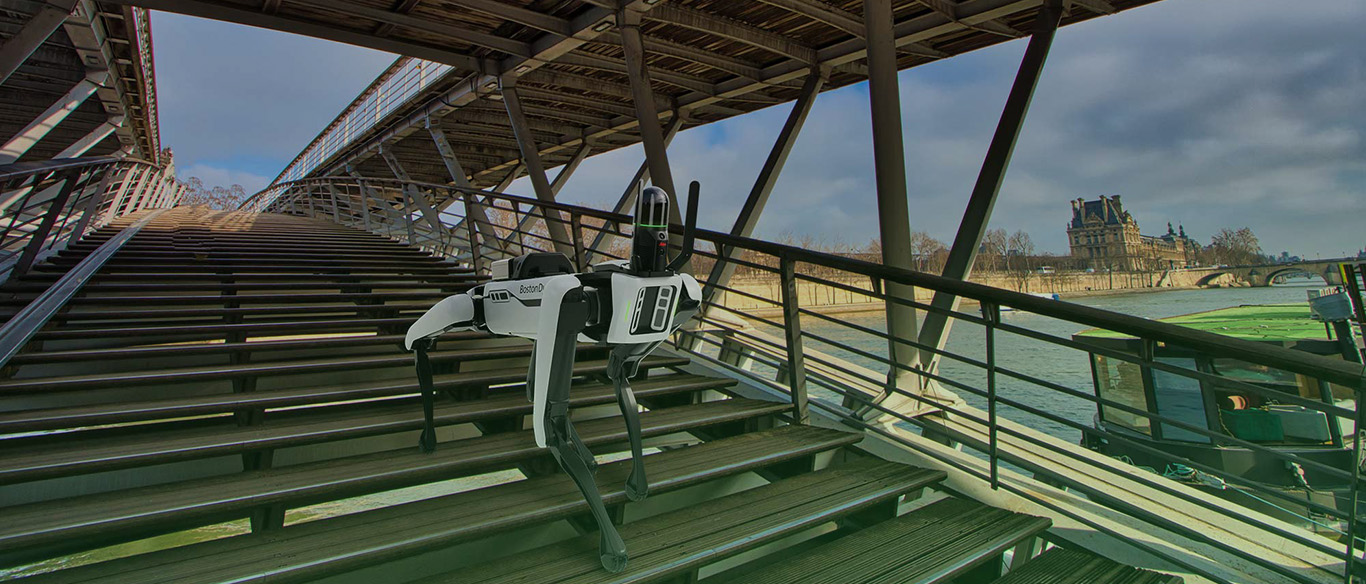
Handheld scanning is one thing, but what if the whole scanning process could be done from the comfort of your office?
The Leica BLK ARC answers that question. An autonomous laser scanning module for robots, the ARC — which stands for Autonomous Reality Capture — lets users control the scanner and robot from the comfort of a tablet or smartphone and even set scan missions that run with complete autonomy.
The BLK ARC’s first integration is with Boston Dynamics’ four-legged Spot® robot. The robotic dog patrols environments on set mission plans while the sensor captures 3D point clouds and panoramic imagery of its surroundings.
Like the BLK2GO, the BLK ARC uses GrandSLAM technology, which combines LiDAR SLAM, Visual SLAM and IMU, and can capture 3D data without human intervention, continuously scanning and storing real-time data while augmenting and improving the robot’s autonomous navigation system.
How the BLK ARC works across environments
Wherever you send it on a mission, the BLK ARC documents ongoing site conditions, saving workers from using extensive time and resources for all-consuming and repetitive tasks. It captures complex structures and environments entirely on its own as it navigates its way through the job site—which could range from industrial complexes and facilities to cultural heritage sites. The solution also protects workers who would have previously been exposed to hazardous environments, such as underground tunnels, by taking on these dangerous tasks alone.
“We saw that with BLK ARC, we could really push towards autonomous reality capture without a human in the loop,” Strupler says. “And if you can achieve that, you can imagine construction sites with a dock where the Spot robot with BLK ARC is sitting, and it’s doing a daily tour, just capturing the whole site. Because of the autonomy, you can scale reality capture, doing these daily scans, which you wouldn't probably do otherwise.”
And Spot is just the BLK ARC’s first mobile integration. Integrations with new robotic carriers will only add to its extensive capabilities in capturing environments.
Taking to the air: the Leica BLK2FLY
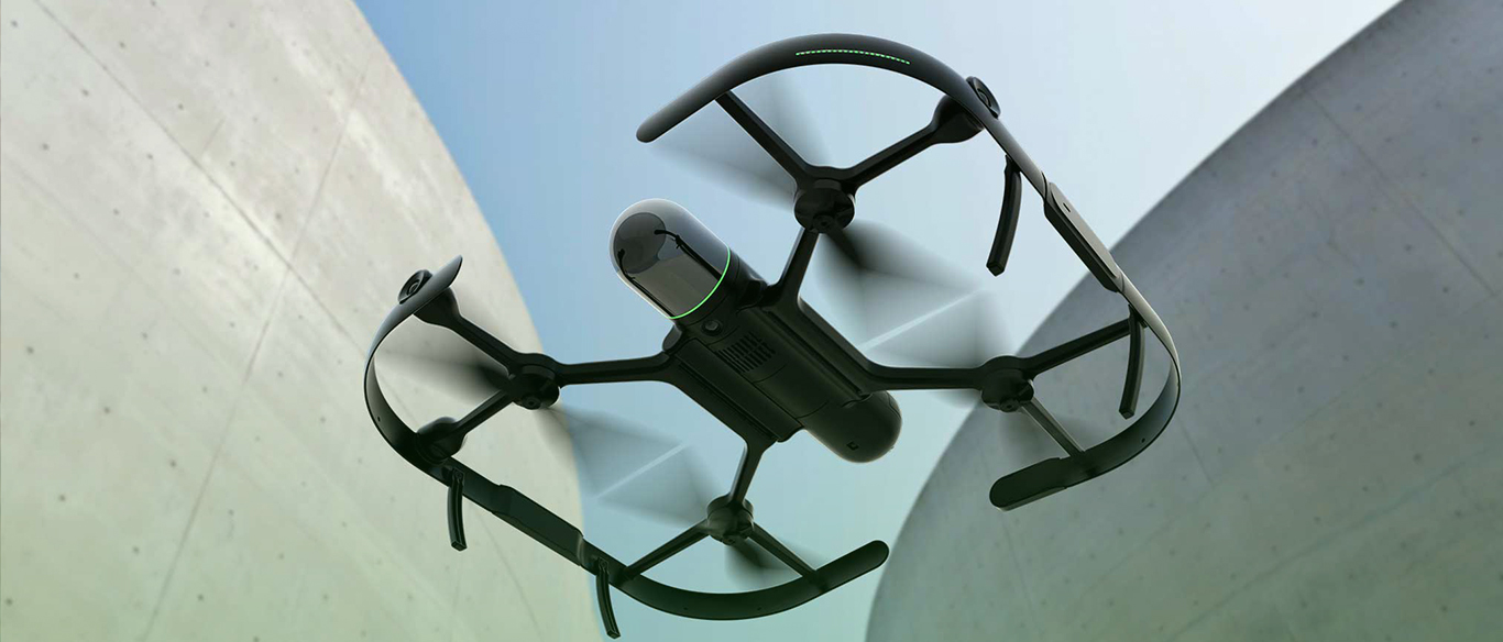
Having ditched the tripod and removed the human entirely from ground-based scanning, there was only one place left to go: the skies.
This led to the creation of the Leica BLK2FLY, the world’s first autonomous flying laser scanner.
While traditional Unmanned Aerial Vehicles (UAVs) scan or take photos with a payload and convert the data to photogrammetric meshes or point clouds, the BLK2FLY creates the point cloud directly in the air, with full integration of all sensors and no external payload, making this solution the first of its kind.
While BLK ARC has eyes on the ground, the BLK2FLY has eyes in the sky, providing birds-eye and close-up reality capture of previously unreachable areas — think rooftops, facades and complex building structures. The BLK2FLY can scan them all with a few taps and swipes on a tablet.
With its airborne capabilities, the BLK2FLY is an excellent tool for building surveys and Building Information Modelling (BIM), construction applications and documenting the construction process, and creating digital twins of buildings. This smart flying scanner will always maintain a certain distance away from structures and other obstacles to avoid collisions and return home for battery changes as required.
How it works
Just mounting a laser scanner on top of a drone wasn’t enough, Strupler says. It had to be as easy to use and intuitive as the other BLK sensors, despite any drone license requirements.
The BLK2FLY’s operation is as simple as possible. Users can plan projects within the BLK2FLY Live app for autonomous flight and scanning or, if preferred, become the pilot using virtual joysticks. A user simply unfolds the device, hits the power button, and starts scanning, viewing the flight in 2D or 3D from the BLK2FLY’s sensors. They can even change the flight path in real-time, mid-air.
“We wanted to put as much autonomy into the operation as possible and make it clear to users that they don’t need to have drone-flying experience to operate the BLK2FLY,” he says. “That’s why we say the BLK2FLY is a flying laser scanner, not just another drone with a laser.”
HxDR and the future

Autonomy isn’t just a mechanical solution but an integrative approach that includes software and complete workflows, and our products prove our initiative to build Smart Digital Realities. But we didn’t stop there.
We’ve driven this initiative forward in new BLK products such as the next generation Leica BLK360, which keeps track of itself in space using its Visual Inertial System (VIS), which automatically combines scans in the field in our Cyclone FIELD 360 mobile device app.
That initiative also continues with HxDR, Hexagon’s cloud-based storage, visualization, and collaboration platform for reality capture data. Once the user has completed their scans using the BLK ARC or BLK2FLY, they can immediately upload the data from the field to the HxDR platform and instantly view and share it.
But planned features for the platform are even more ambitious — and more autonomous.
“For me, autonomy doesn't stop with capturing. It needs to continue with the processing of the data,” Strupler says. He’d like to see a future where registration and meshing of scans can be autonomous too.
“This is also part of why we started HxDR, to have kind of a sandbox for such autonomous algorithms,” he adds.
Handheld. Airborne. Robotic. From speedy mobile mapping on foot to robotic scan missions on the ground and seamless capture of exteriors and roofs from the sky, the Leica BLK Autonomy fleet offers agile scanning solutions designed to bring fast, autonomous reality capture to users around the world. Whether your profession is construction, design or preservation, Leica Geosystems, part of Hexagon’s technology will take you to the cutting edge of our autonomous future.