 RTC
RTC
 BLK360
 BLK360 SE
 BLK2GO
 BLK ARC
 BLK2FLY
 BLK3D
BLK3D
 Tilbehør

A monumental column facade, a light-flooded glass dome, striking architectural symmetries: the Kurhaus Wiesbaden is a magnificent neoclassical building. To carry out a comprehensive renovation, the architects needed a complete, precise digital image of the building. The surveyor’s firm they contracted, Vermessungsbüro Frommelt GmbH, opted for solutions from Leica Geosystems: a combination of stationary and mobile laser scanning, as well as an end-to-end workflow from data collection to analysis. The project is a prime example of how even complex surveys can be performed efficiently and shows the role technology, experience and the interaction of systems play in this process.
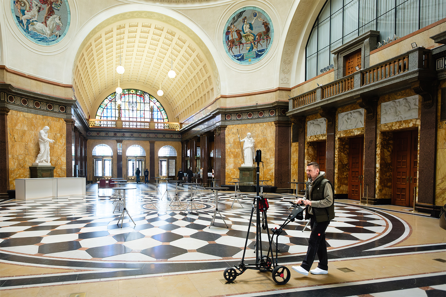
The foyer of Kurhaus Wiesbaden is an impressive space: high ceilings, ornate columns, sweeping vistas. Today, Wolfgang Dienesch is the only person moving around in there, calm and focused - which is somewhat exceptional. He is pushing a compact scanning cart in front of him, on which the Leica BLK ARC is mounted. As he moves forward step by step, the system continuously records its surroundings. Walls, room edges – every structure becomes part of a growing digital image.
Wolfgang Dienesch is Managing Director of Vermessungsbüro Frommelt GmbH and is here with a clear mission: to record the Kurhaus in full, inside and outside, from the basement to the roof, as the basis for planning upcoming renovation work. It used to take months or even years to scan individual data points separately, but today a high-density point cloud can be generated in just a few weeks – precise, complete, connectable.
For Dienesch, this job is more than a project: “As someone born and raised in Wiesbaden, the Kurhaus is, of course, something very special to me. When the request came in, I knew right away that we would take the job. The fact that we can even capture such a building in this form today is all down to the technology. With solutions from Leica Geosystems, we are able to efficiently record even complex structures efficiently and ultimately deliver reliable data.”
The mission: a digital basis for a complex existing building
The Kurhaus Wiesbaden is one of the most famous historic buildings in the Hesse state capital. Built in the early 20th century according to the plans by architect and painter Friedrich von Thiersch, it remains a symbol of the combination of grand architecture and multifunctional use to this day. With its halls, colonnades and the adjacent spa gardens, it serves as a venue for conventions, cultural events and social functions. At the same time, it is a technically complex building that has grown and undergone numerous structural modifications over the decades.
For a comprehensive renovation, starting with the Kurhaus’s entire kitchen area, the contracted architectural firm Zaeske required a reliable basis for its planning. The problem was that the Kurhaus is a historical building that has been extended multiple times, which meant that the as-built plans were incomplete, inconsistent or lacked the required level of detail. So, a precise, complete digital image (digital twin) of the entire building was needed, from the basement to the roof, including facades, technical areas and all relevant structures.
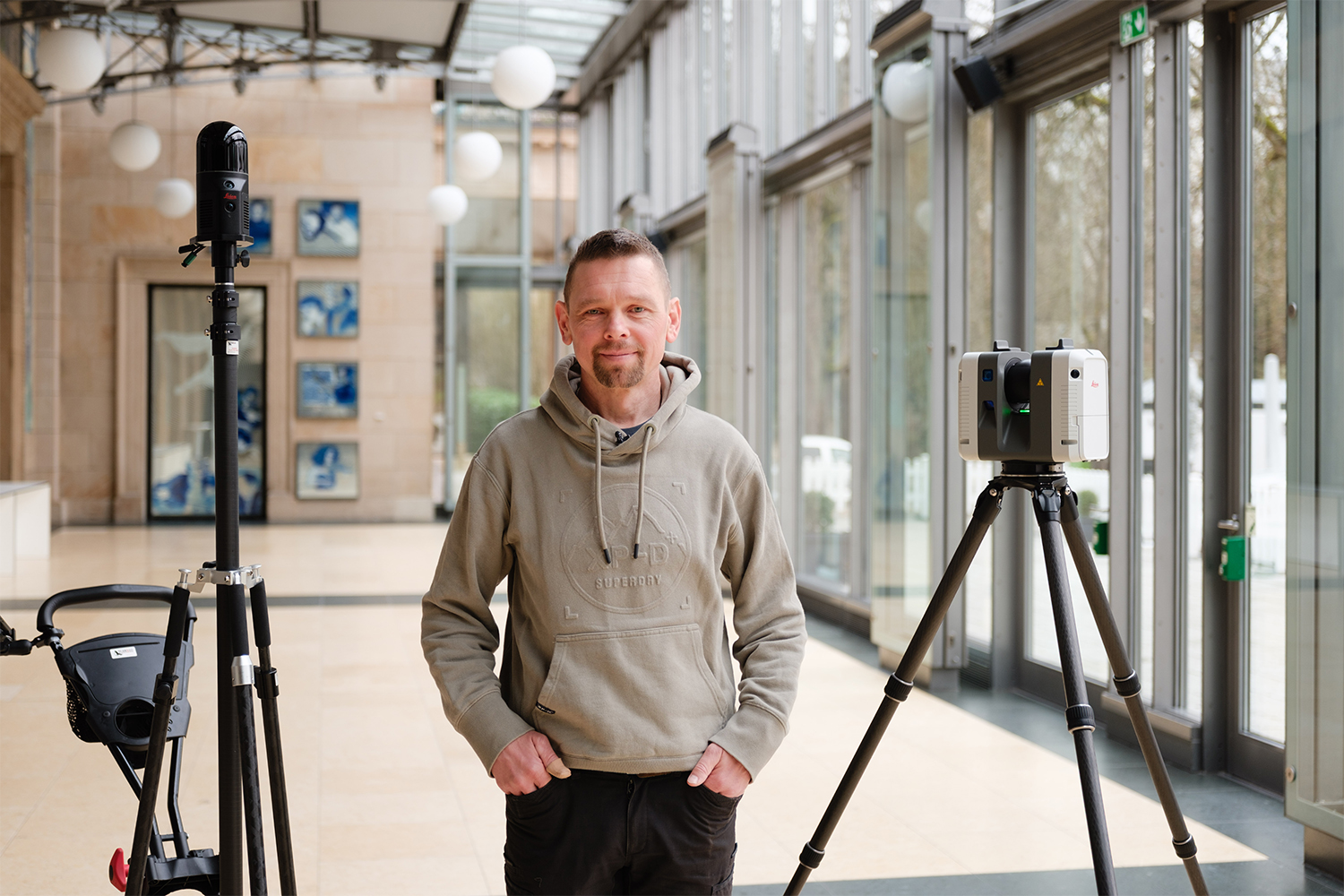
Surveyor’s firm Vermessungsbüro Frommelt was entrusted with this task. It had been working with the architectural firm for many years, so Dienesch was involved in the planning process at an early stage. Wolfgang Dienesch explains: “Early last year, the architectural firm indicated that it would be needing some surveying work carried out in the Kurhaus and asked whether we had the staffing and technical capabilities to handle it. We knew that it would be a challenge, given the sheer size of the building. But we wanted to tackle the project. When it became more concrete, we invested in a mobile laser scanner, the Leica BLK ARC, alongside our existing scanners, so we could efficiently capture large interior areas during ongoing operations. Shortly after that, we were awarded the contract.”
Efficient surveying thanks to combination of stationary and mobile scanners
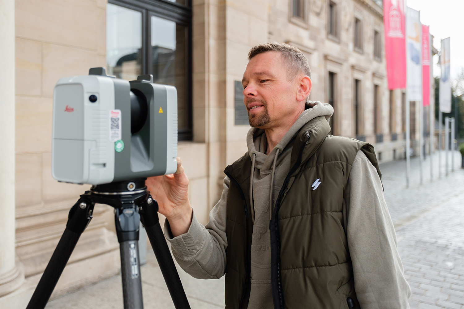
The Kurhaus survey was carried out on the basis of a georeferenced grid of control points, which ensures the linking of the exterior and interior scans. Frommelt combined stationary and mobile laser scanning, integrated into a joint control point and registration concept and tailored to the building’s requirements. For the outdoor area and areas requiring a particularly high level of detail, the Leica RTC360 was used. This static laser scanner delivers high-resolution point clouds and is especially well-suited for facades, ornate architectural elements and complex geometries. Thanks to the fast scanning speed and the automatic preregistration of individual scans – which are known as walks – directly on site in the Leica Cyclone FIELD 360, it can capture numerous scan positions in a short space of time and link them together seamlessly.
Indoors, the team, consisting of Dienesch and a colleague, also used the mobile laser scanner Leica BLK ARC, which is moved around the building on a scanning cart and enables a continuous capture of large surfaces, even across multiple rooms. This is based on the combination of LiDAR SLAM and Visual SLAM: alongside the pure laser data, the system also uses visual features such as edges, doorways or structures for orientation within the space. The individual walks are continuously registered and linked to the static scan positions. In complex interior spaces especially, this ensures a reliable determination of position and the scans can be effectively linked up. The system’s strengths really come into play in spacious areas such as foyers or halls, as fewer individual station points are required and the scanning process is significantly accelerated.
Around 40,000 square meters were captured in total, from the basement to the attic, including all secondary areas. The combination of the two systems proved key to the efficiency of the project. While the Leica RTC360 is deployed wherever a maximum level of detail is required, the Leica BLK ARC enables rapid, wide-area capturing of room structures. The exterior and interior scans are linked up using control points that are set up outdoors and transferred to the interior. On this basis, the scans from both scanning methods can be accurately aligned and analyzed within a common coordinate system. A complete digital twin of the building is thus created in a relatively short amount of time. “With conventional tacheometric scanning – in other words, point-by-point data collection via angle and distance measurements and free stationing – we would have had to take point-by-point measurements for months on end for a building of this size. Today, we are much faster on site. That makes projects like these now economically viable for the first time,” Dienesch says.
From the point cloud to a workable plan
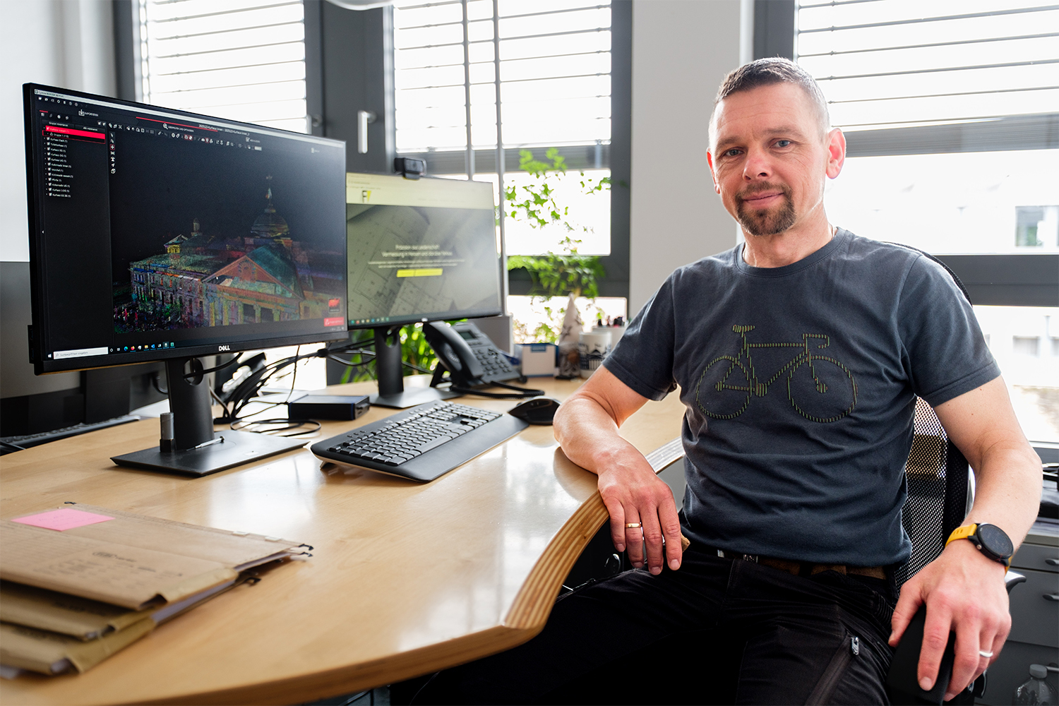
The actual analysis process then begins in the office. This is where the scan data is consolidated, processed and converted into a solid basis for planning. Frommelt used the software Leica Cyclone REGISTER 360 PLUS, in which the individual scans from both sensors are first automatically preregistered and then consolidated into a consistent overall point cloud using cloud-to-cloud methods. The software supports this process through automatic preregistration, visual inspection and precise post-processing. Step by step, this creates a seamless, three-dimensional model of the entire building.
Dienesch explains: “Bringing the individual scans together seamlessly is like doing a jigsaw puzzle. The software helps us enormously, as many of the steps are already automated, while we still maintain full control over quality.”
The next step is to clean the point cloud with the Leica Cyclone 3DR software, which uses classification and filter processes (e.g. automatic detection and removal of people, furniture and temporary objects) to create a clear, streamlined dataset. The automated functions process large volumes of data smoothly and substantially reduce the amount of manual work required. But there is still work to do. While data collection on site is relatively quick, processing the data in the office takes more time. This, however, is where the key added value lies: from millions of survey markers, a structured, reliable foundation is created on which the architects can confidently continue their work.
“Many people underestimate how much work is involved in analyzing the data,” Dienesch says. “But this is precisely where the quality is created. In the end, we don’t deliver a point cloud, but plans that can actually be used.” The combination of rapid data collection on site and high-performance processing in the office enables an end-to-end workflow, from the first scan to the final basis for planning.
Continuity in technology and workflow with Leica Geosystems since 2001
Vermessungsbüro Frommelt has been working with solutions from Leica Geosystems for more than two decades. The collaboration began with the first total station in 2001. The surveyor’s firm then continuously expanded its portfolio, from additional total stations to GNSS systems to the laser scanners and analysis software used today. Dienesch notes: “We started with Leica Geosystems back then and have stuck with them ever since. The devices are precise, the operation is well-thought-out, and we can count on everything working together reliably, from the work on site to the analysis.”
One key factor here is the end-to-end continuity of the workflow. The hardware on site and the software in the office work seamlessly together, so data can be processed without interruption, and processes remain consistent. It is with complex projects like the Kurhaus Wiesbaden that the advantages of a harmonized system are most apparent.
Added to this is the technological progress factor. New generations of equipment enable the company to expand its range of services and take on additional projects that would barely have been economically or technically feasible in the past.
“The new scanner technology has opened up an entirely new line of business for us. We wouldn’t have been able to tackle such projects in the past. Today, we can efficiently capture large and complex buildings and deliver a whole new level of data quality to our clients.” This is also to the clients’ advantage. Greater efficiency in data collection and precise analysis result in a reliable basis for planning in less time. At the same time, new opportunities to use the data open up – for digital models or further analysis, for instance.
Reliability across the whole project
Besides the technology itself, Dienesch singles out another key aspect in his daily project work: the service and support from Leica Geosystems. He explains: “The support Leica provides is excellent. We have a designated contact person, can reach someone quickly and receive concrete assistance. This is extremely important in a project of this scale, because you can’t afford any long periods of downtime.” Technical questions, the coordination of data processing or ad hoc issues can be resolved quickly, without endangering the project’s progress.
Ultimately, what remains for him above all is an experience of an exceptional project: “Surveying the Kurhaus was, for me personally, the highlight of my career so far. I was familiar with the building, but walking through and taking in every room, every hallway and every area gave me a completely different understanding of it. That was something special.”
For Dienesch, the fact that a project of this scale can be carried out efficiently today and in the quality required is clearly thanks to the technology used: “The combination of solutions by Leica Geosystems on site and for data analysis was the key factor. Not only were we able to execute the project, we were able to complete it to a level of quality that both we and our client are very satisfied with.”
