 RTC
RTC
 BLK360
 BLK360 SE
 BLK2GO
 BLK ARC
 BLK2FLY
 BLK3D
BLK3D
 Accessories

A significant part of Switzerland's water resources reservoir resides in its complex karst aquifers, a critical natural system that continues to pique the curiosity of researchers. At the Neuchâtel Centre for Hydrogeology and Geothermics (CHYN), a team of scientists, led by Professor Phillipe Renard and accompanied by climate scientist Dr. Tanguy Racine, launched an initiative seeking an in-depth understanding of these resources.
The objective was clear: to study the physics of water flows within caves or underground karst conduits using innovative technology – specifically, 3D laser scanning with the Leica BLK2GO and a customized lighting unit from Méandre Technologie – to bridge the gap in understanding aquifers that traditional measurement and modeling methods couldn't cover.
Delving into the shapes of underground karst
According to the United States Geological Survey, “[k]arst areas are characterized by distinctive landforms (like springs, caves, sinkholes) and a unique hydrogeology that results in aquifers that are highly productive but extremely vulnerable to contamination.” For the karst aquifers studied by CHYN, the project involved detailed mapping of the karst caves’ internal surfaces to understand water flow and contamination, among other factors.
Creating digital twins incorporating 3D point clouds, colorful panoramic images, and high-resolution meshes was the objective. The team took their explorations to various locations, including the Waterfall Cave in Môtiers and the Vallorbe cave.
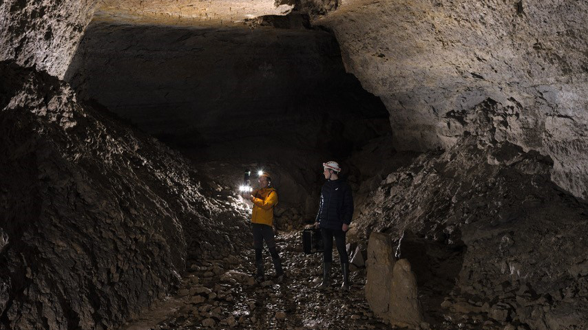
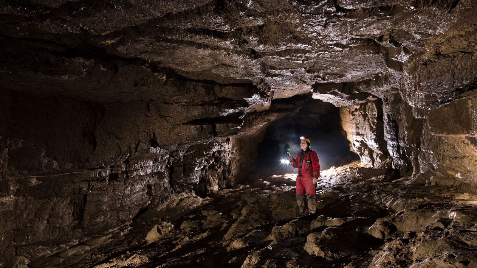
Navigating the journey through kilometers of karst conduits required cutting-edge mobile scanning technology. BLK2GO was chosen as the tool to support the endeavor, offering a valuable solution for this task that required an efficient way to capture the complex geometry accurately. With the BLK2GO, researchers could map large areas quickly and with greater mobility than traditional scanning.
Capturing each distinctive feature, may it be a shaft, tunnel, or scree area, the efficiency of BLK2GO enabled the team to adapt their data capture strategy accordingly to capture all areas needed. What may not have been measurable before soon became accurate 3D point clouds of every area that researchers needed to document.
Illuminating the dark underground network of caves
One of the key challenges of this underground expedition was adequate lighting. In a naturally light-deprived environment, ensuring the BLK2GO could effectively capture all data was crucial. Creating colorized point clouds relies on lighting, which scanners typically do not provide themselves – they either rely on natural or artificial lighting to illuminate the scene, which allows for images to be captured, which then colorize the data captured with LiDAR.
However, researchers were up to the challenge of finding a solution of providing the required amount of lighting needed to capture colorized point clouds while on the move.
The team used a specialized lighting system designed by Méandre Technologies. This add-on lighting unit, which easily attaches to the bottom of the lightweight BLK2GO handle, illuminated the conduits, empowering researchers to capture each detail they needed by combining geometric with color data, a huge benefit to their work.

Creating digital twins of aquifers and conduits
On their return from the field, the next step was processing the acquired data. Using Leica Cyclone REGISTER 360 PLUS software, they processed and cleaned the colorized 3D point clouds, condensing them into an accessible form to perform an efficient geomorphological analysis.
Subsequently, they created several meshes in Leica Cyclone 3DR, shedding light on the geometric characteristics of the karst conduits.
A noteworthy challenge encountered during this study was that GNSS was not available underground to measure control points, and the team needed to create a continuous point cloud from the cave system. Relying on GrandSLAM technology, the team was able to capture the karst caves efficiently. When scanning distances longer than a hundred meters, the team scanned in closed loops, ending the scan where they started. That way the BLK2GO can recognize identical features to align the long point cloud correctly, and researchers could confirm that the 3D model of the cave hadn't shifted along the long walks.
Analyzing underground water networks
The detail-rich digital twins, captured by the BLK2GO and created by the team, were critical in examining and synthesizing the geometry of the underground water conduit networks. For instance, their use for modeling how fast waterborne contaminants are transported underground is invaluable. With 3D data representation in hand, the scientists could monitor potential contamination hotspots and assess the vulnerability of water resources through analytical perspectives. This proactive measure promises to improve environmental health and manage water resources efficiently.
When it came to estimating water flow capacity, the digital twins proved instrumental. Understanding the geometric details of karst conduits, their shape, the flow characteristic at each twist and turn, and the presence and spatial relation between features causing drag is vital for accurate flow estimations. By measuring and taking cross-sections of karst aquifers with the BLK2GO data, the team could build reliable predictive models for water flow, efficiency, and capacity within these conduits. This data proves influential in managing water resources and shaping policies for sustainable water use.
Advancements in karst aquifer studies
The project exhibited the robust capabilities of the Leica BLK2GO and shed light – literally! – on the promise that handheld 3D laser scanning technology holds in advancing the understanding of natural resources. The BLK2GO successfully captured data in a single field trip, eliminating the need for several field visits and maximizing the project's overall efficiency and effectiveness.
For Dr. Racine and the team at CHYN, the BLK2GO met the demands of capturing confined, dark underground environments. Its ability to quickly and reliably capture datasets in these conditions, especially in combination with the Méandre Technologie lighting unit, paved the path for a deeper understanding and utilization of Switzerland's significant water resources.
As we move forward with climate studies and understanding how to sustainably manage water resources, the idea of scanning previously unreachable spaces, capturing previously inaccessible data, and, in turn, understanding our ecosystem better will guide researchers toward a complete understanding of the aquifer systems at Môtiers and the Vallorbe cave.
The work by Dr. Racine and his team shows us a future where technology serves as the medium connecting us to underground water networks that were either hard to reach or difficult to measure and monitor. These scientists are now learning precisely how these aquifers, conduits, and caves work, which helps researchers and public works officials to monitor and create more sustainable uses of water resources.
Success comes when careful planning meets clever technology. Learn more about handheld scanning with the Leica BLK2GO here.


