
Designed for any carrier. Attach the BLK ARC onto any carrier, robotic or manual. The choice is yours to make.
Go off the beaten path, take on a different challenge, and perform reality capture almost anywhere and in any way with the BLK ARC.
The BLK ARC is an incredibly versatile scanner, which means you get to choose how you use it. While it excels at autonomous reality capture, it can be used precisely how you want – robot or manual, with static and mobile scans – so you can capture exactly what you need, where you need it.
While you can dive straight into the world of robotics with the BLK ARC, sometimes starting your journey with a non-robotic carrier that suits your projects, job sites, reality capture needs, and data deliverables may be the best choice.
Either attach the BLK ARC to Boston Dynamics’ Spot, build a custom integration of the BLK ARC with your carrier, or attach it to a backpack, a pushcart, or even a boat—this empowers you to take complete control of how you capture data with the BLK ARC.
With the BLK ARC, anything is possible. It’s a truly unique scanner with the versatility to mount onto anything and capture dynamic and static scan data.
- Johannes Hotz, Business Lead Leica BLK ARC at Leica Geosystems
But don’t take our word for it. Our customers have explored various creative ways of utilizing the BLK ARC, and we’re excited to present some of their solutions. Let’s look at some of the implementations of the BLK ARC that are digitizing the world.
Hit the streets rolling.
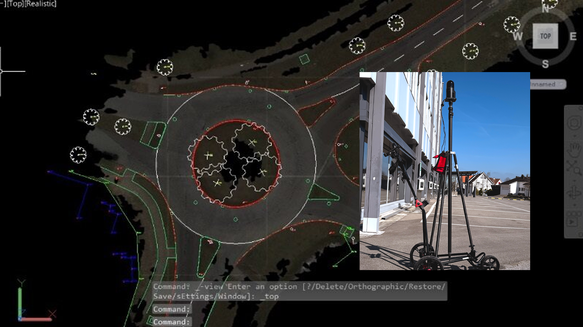 Image credit: Anne Pitkaenen
Attached to a manual pushcart, the BLK ARC smoothly maneuvers its way onto concrete, gravel, paved roads, and through indoor corridors. Manually push the BLK ARC to capture structures and areas and move intuitively around the environment to digitize everything you need. Complete the data by combining traditional surveying methods like a total station or GNSS with reality capture data from the BLK ARC, for a complete topographic survey. Get all the details with less time on the roadside and on-site and finalize your CAD drawings in the office.
Digitize your construction sites.
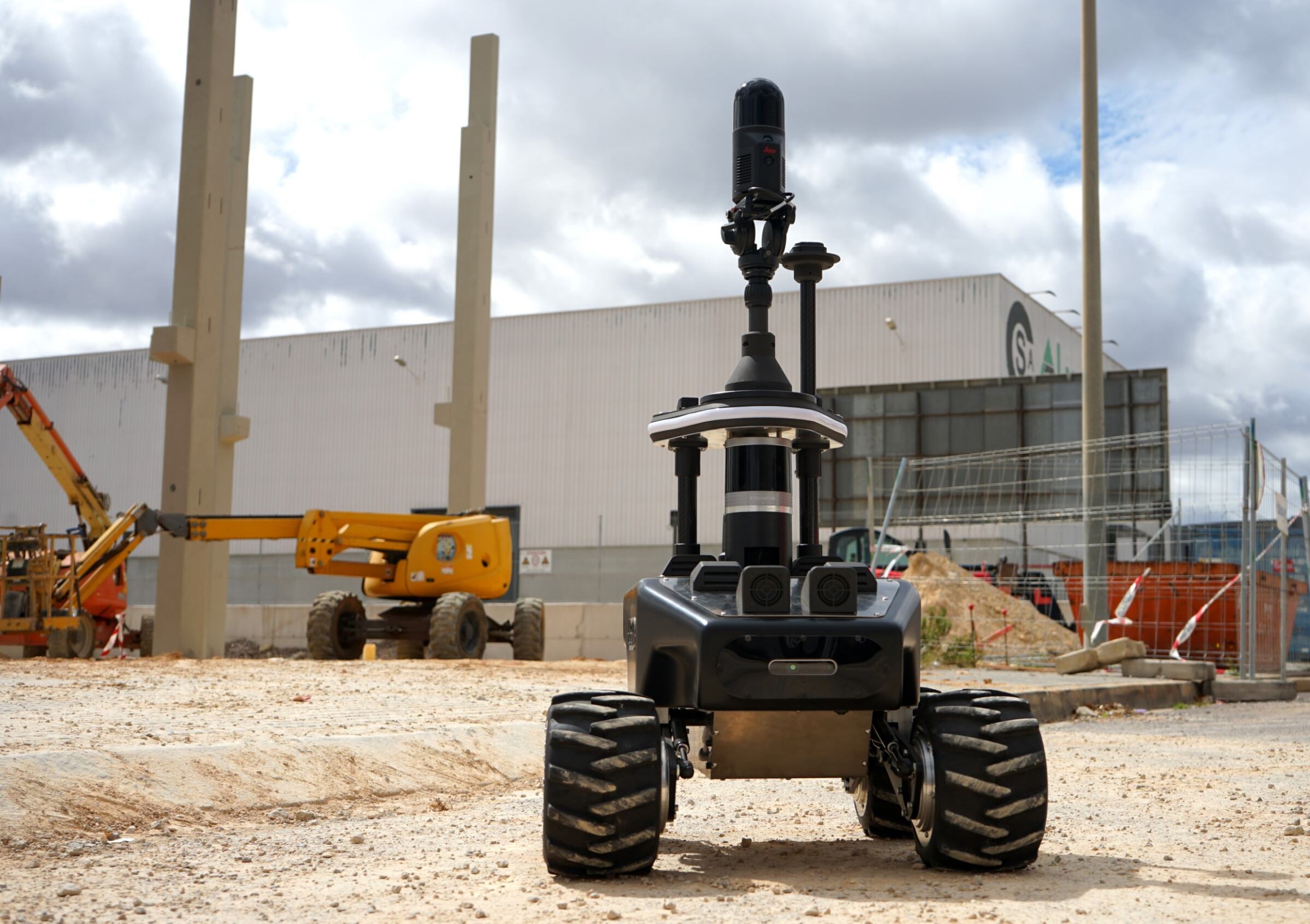 Image credit: Robotnik
In this photo, attached to the RB-WATCHER, the BLK ARC charges ahead, up and through gravel, to capture the site thoroughly and precisely. When the BLK ARC is attached to a durable carrier designed to travel through construction sites, teams can remotely capture all the necessary data without setting foot on the site, avoiding dangerous areas and difficult terrain.
Scanning the city underground…
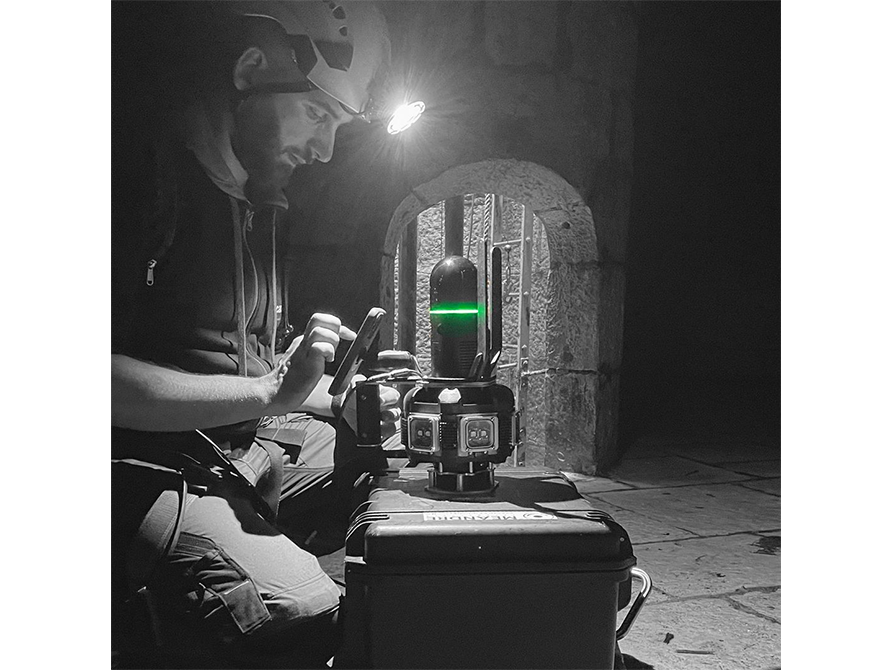 Image credit: Hugo Parent
Here, the BLK ARC uncovers secrets hidden in inaccessible areas of an ancient French waterway. Lowered down by a pulley system, the BLK ARC can make its way down tight elevator shafts, modern wells, and ancient water containers. Here, it arrives safely to scan the empty water cistern of Besançon, built centuries ago in northeastern France.
…and even city sewers!
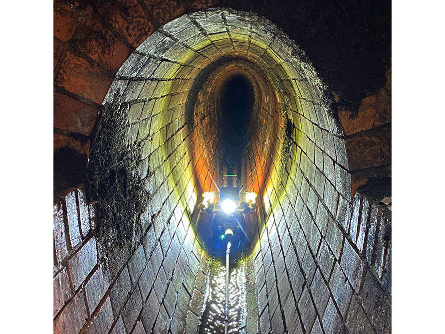 Image credit: Lüdeke Grasshoff
Taking an industrial approach to scanning, the team here attached the BLK ARC to an IBAK channel TV trolley – sending in the BLK ARC to document the sewers while keeping their surveyors out of harm’s way. In tight, enclosed spaces, workers stay remote and monitor the quality of the data being captured from a safe, accessible area.
Scanning and underground documentation all at once!
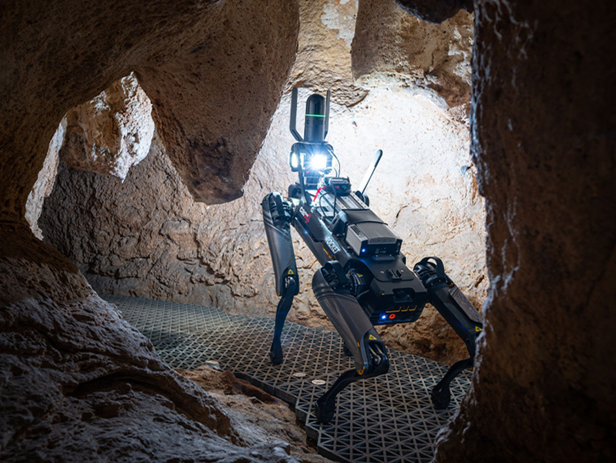 Image credit: Thibault Poinas and Rémi Flament
The BLK ARC on Capture4cad's ROCKET steps its way through the jagged and tight cave, avoiding stalactites and scanning the cave's prehistoric engravings and paintings. For projects with limited human access and strict photography restrictions, the BLK ARC delivers detailed imagery for teams via its forward-facing camera system for geo-tagged images within the point cloud. This implementation of the BLK ARC brought engravings and paintings of more than 15,000 years old back to life digitally.
A pulley system for scanning a deep, narrow well!
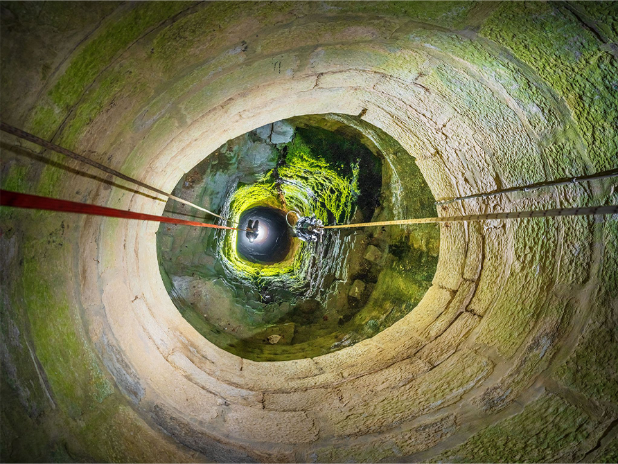 Image credit: Hugo Parent and Rémi Flament
The BLK ARC travels down a 110-foot well for digitization and documentation. Here, it is attached to a pulley system for an unobtrusive, linear, controlled way to scan such a narrow and deep space. Utilizing the BLK ARC this way enables smooth navigation, and now, the team has a 3D digital twin of the historic well for both preservation and reference.
Or send it out on the water!
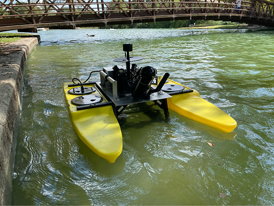 Image credit: Abyss Solutions
Here, Abyss Solutions attached the BLK ARC to a remote-controlled boat to scan their floating platforms and monitor their equipment and structures. Bringing mobile scanning to the water, you can capture data of hard-to-reach areas like floating platforms, aqueducts, bridges, and other waterways.
High in the sky attached to a crane.
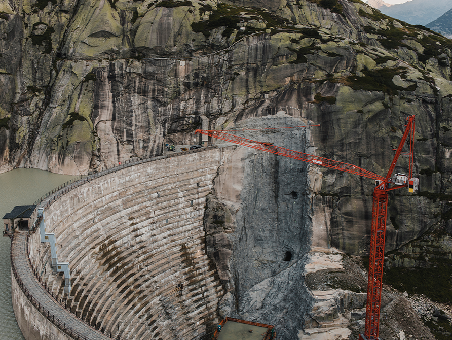
Capture scan data from high up and mount the BLK ARC onto a crane to monitor massive structures like dams. Our customers are currently at work attaching the BLK ARC to cranes to suit their various needs. By mounting the BLK ARC onto their existing toolkit, users can capture essential details of massive structures and large sites for all their surveying and digital documentation needs, even if that tool is a giant crane.
Remote control car or a small buggy
Reach small, tight spaces, like inside suspended ceilings, to document HVAC or electricity installations. Some customers use a standard RC car or similar, more rugged solutions from professional vendors to take the BLK ARC where humans can't fit.
Carry it yourself.
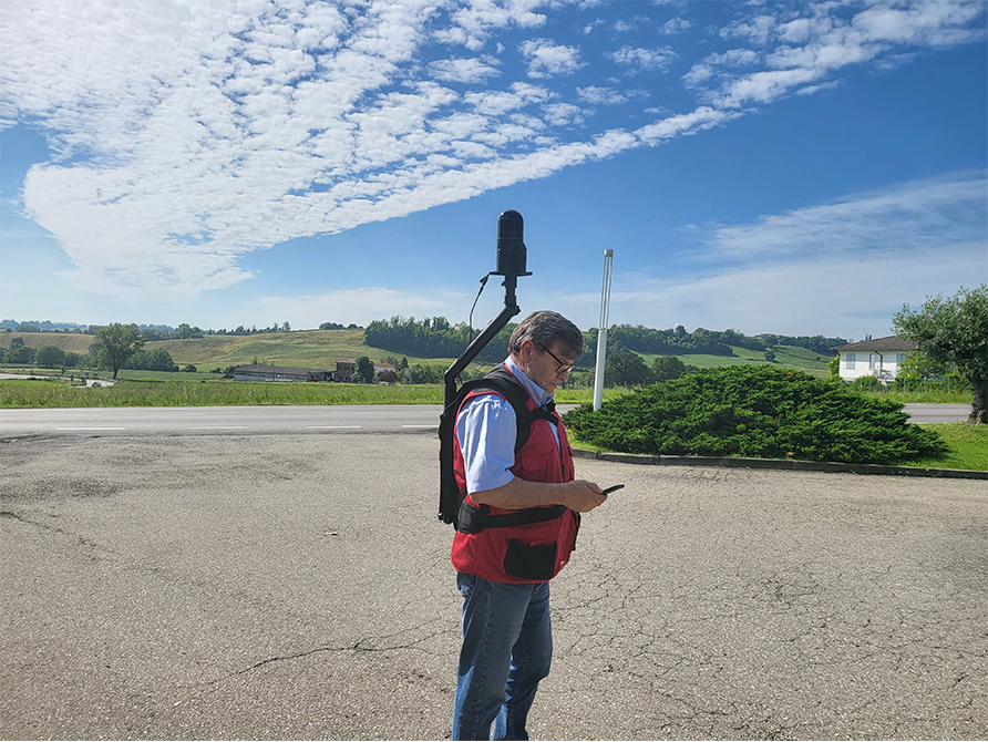 Image credit: Massimo Secchia and Scan&Go
With the BLK ARC attached to a backpack, you can move exactly how you want, where you want. Whether capturing scan data for warehouse inventory or surveying the accessibility of city streets, the BLK ARC weighs less than 4 kilos (just under 9 pounds) while attached to a backpack. This keeps scanning light and easy on your back, so you can keep scanning for hours.
Show us your work with the BLK ARC!
Decide where the BLK ARC goes next and embrace the versatility to scan precisely how you want with any carrier that best suits your needs. Contact our reality capture specialists to learn more here.
We can’t wait to see what you’re up to with your BLK ARC. Tag us at @LeicaBLK on social media and we might even feature your work!