RTC
RTC
 BLK360
 BLK2GO
 BLK ARC
 BLK2FLY
 BLK3D
BLK3D
 Tilbehør

For most 3D laser scanning projects, the workflow hasn’t changed dramatically in years. Data is captured in the field, physically imported for final registration when back to the office, and only then shared for further production. Each stage waits for the previous one to finish.
The process is sequential by design, and that has a cost.
Project timelines stretch because the pipeline is linear. Teams with the capability to deliver faster are constrained.
In a market where clients expect shorter turnaround times and where competition for project work is intensifying, that constraint is increasingly difficult to absorb.
The workflow is the problem
The industry hasn’t stood completely still. Leica Cyclone FIELD 360 companion app brought registration into the field in 2018, reducing some of the manual work that previously waited until data reached the office.
This will remain an important part of the workflow, but it doesn’t change the fundamental shape of the problem. The field and the office are still two disconnected environments. A project manager in the office has limited visibility into what’s happening on the site 100 miles away until the data physically arrives. If someone forgets to scan an area, there’s a chance nobody finds out until final registration begins back in the office.
Blind spots can emerge as soon as the project scales. If a project involves multiple scanner operators working in parallel, nobody knows exactly what the other person has captured until the data is merged back in the office. Coordinating efforts to ensure total site coverage often relies on common communication methods and informed guesswork. Operators often end up over-scanning to be sure, wasting time.
These are structural problems rather than software problems. The workflow itself is the problem. Reality capture has changed.
Real-time collaboration is the new standard
Using today’s wireless networks, we can effectively remove the gap between field and office. That is the premise of Livelink, introduced alongside the new Leica RTC series.
Livelink connectivity enables project teams to capture, connect, and collaborate in real time. It seamlessly connects scanning members, field coordinators, and office teams into a single live project environment within Cyclone FIELD 360 while data capture is still underway. This means data doesn’t wait to be transferred. As each laser scanner captures, preview data syncs via a shared Livelink scene in Hexagon GeoCloud to every connected mobile device and to the office simultaneously.
Registration can begin before the final setup is complete. Production can start before the team leaves the site. From there, data can be transferred to Leica Cyclone REGISTER 360 PLUS for further registration and analysis.
The sequential workflow becomes parallel. Livelink significantly changes the dynamics and economics of a typical project.
The benefits of Livelink in practice
Time to delivery, compressed
Capture, import, and registration can now all happen at the same time. Office teams are no longer waiting for a USB stick or hard drive to arrive. That means deliverables are shared with clients much faster than before.
The 3D laser scanning market is growing, meaning there are more projects available to take on. But competition is also intensifying. By significantly shortening the time to final deliverables, Livelink helps companies outpace others who are stuck in linear workflows while also freeing up their teams to move on to the next job sooner.
Full visibility across the field
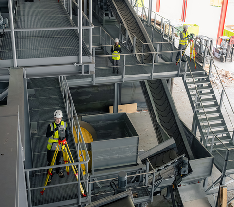
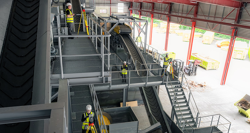
When multiple RTC laser scanners are deployed on a single project, each operator in the field and office can see the full shared picture through a shared Livelink scene in Cyclone FIELD 360 and GeoCloud. They can see what’s been scanned and where gaps remain.
The benefits for medium-to-large scanning projects are evident. Imagine a tunnel survey with two operators working inward from opposite ends. Each operator, and even the office team, can see exactly where the other has reached, made even easier because other people’s setups are displayed using different colours.
This ensures seamless coverage with no scanning overlap or missed areas. It also avoids costly site revisits where someone has to go back to the site to capture more scans because something was missed, further delaying the project.
Picture a high-rise construction project spanning multiple floors. All field members can coordinate across levels in real time, redirecting resources the moment a section is complete rather than doubling up unnecessarily.
Livelink ensures completeness, avoids site re-visits, and means everyone leaves the field with 100% confidence on a job well done.
A new kind of field role
Livelink helps reorganise a scanning team into a more efficient operation. A senior scanning expert can now act as a scanning coordinator operating between the field and office teams.
This person monitors incoming data from the field, manages registration, and intervenes if an area has been missed before everyone moves on.
They can also actively process the project in Cyclone FIELD 360 while capture is ongoing, bundling setups, taking measurements, or even generating immediate field deliverables like floor flatness analysis before everyone leaves the site.
For larger scanning projects with multiple RTCs, this role transforms what used to be a difficult dance of coordination into a managed operation.
More accessible to larger, mixed-ability teams
Because the scanning coordinator can handle registration, individual scanner operators can focus entirely on data capture. This means junior team members don’t need to be fully trained on registration workflows before they can start scanning. That expertise can now sit with one person as others are trained. Organisations can scale their scanning capacity without proportionally scaling their specialist training requirements.
Smart data management, built in
Livelink comes with the option of syncing preview data within GeoCloud. This keeps data uploading smoothly from the field without slowing down the network or forcing massive file downloads. Users can download full scan data from the RTC to Cyclone FIELD 360 for target fitting or more precise registration.
The full, high-density scan data stays securely on each individual laser scanner until downloaded for final registration, intensive analysis and advanced deliverables. Teams get real-time visibility without needing to move large datasets at every step.
And if internet connectivity drops, the workflow doesn’t break. Livelink simply retains all data synced up to that point. It pauses, and then automatically resumes syncing the moment the connection is restored.
Built for where the market is moving
Single-scanner workflows remain the backbone of the industry. Here, Livelink enables users to store data in GeoCloud for secure access and easy sharing back to the office.
At the same time, scanning teams are getting larger and more distributed. Workflows increasingly need to support single-operator setups and larger, multi-user environments.
For both environments, client expectations around delivery timelines are not going to ease. Livelink in Cyclone FIELD 360, enabled by the new RTC series, is a direct response to where the work is today, and where it’s heading.
As Livelink evolves, users can expect deeper collaboration capabilities, even more automation in data handling, and even simpler field-to-office syncing.
Learn more about the Leica RTC Series and Livelink capability in Leica Cyclone FIELD 360.
For a detailed technical walkthrough of the Livelink capability, download our whitepaper.

Chiara Francolini
Product Manager
Reality Capture Software