
In 1921, our founder Heinrich Wild established a legacy that shaped modern surveying as we know it, inventing precision tools and aerial cameras that revolutionized the way we measure and map our world.
A century later, Leica Geosystems – part of Hexagon, continues to innovate with our award-winning Leica BLK Series of reality capture sensors. From the portable, easy-to-use Leica BLK360 imaging laser scanner to our handheld BLK2GO, the company has sought to break the mold – and then break it again – democratizing reality capture in the process.
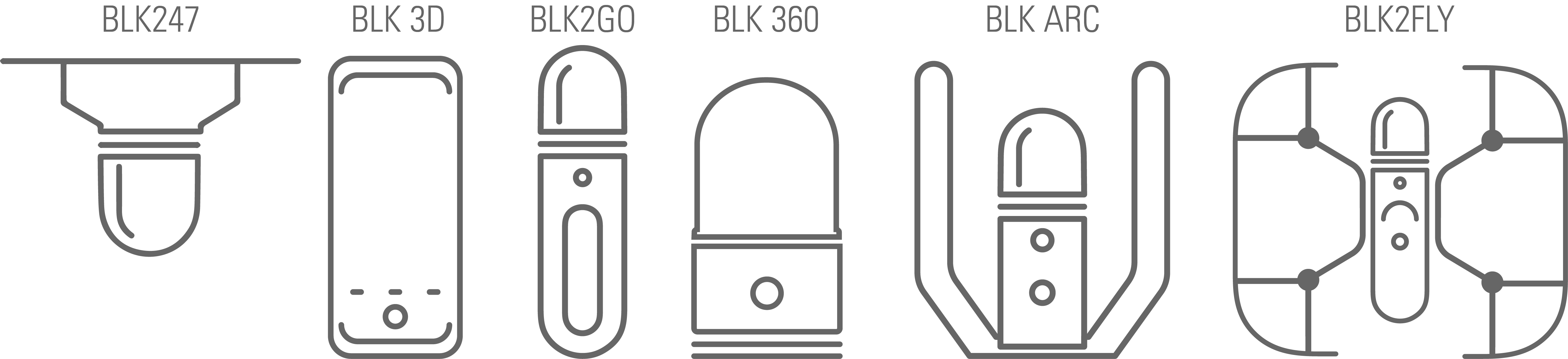
In 2021, we introduced the world to the BLK ARC, an autonomous laser scanning module for robots, and the BLK2FLY, the world’s first LiDAR-based Unmanned Aerial Vehicle that performs fully autonomous reality capture from the sky. With a complete line of six BLK devices—the BLK360, BLK3D, BLK247, BLK2GO, BLK2FLY, and the BLK ARC—builders have delivered structures off-site with no setbacks; visual effect artists work confidently, mapping their digital assets precisely to their real-world counterparts; and architects render what was once invisible visible through digital reality.
But it all started with a bet.
Contents: A 3D Scanner the size of a Coke Can | Customers React | Beyond the BIM | Going Extra-Terrestrial | Redefining Mobility | Visions of an Autonomous Future | Democratizing Reality Capture
A 3D Scanner "The Size of a Coke Can"
“As I was told, there were a couple of high-level senior executives having a conversation sitting around a conference table and a guy was drinking a Coke and he says, ‘I want a laser scanner that is this big’ and he set it down on a table. ‘That's what I want,’” said Hugh Baertlein, Vice President of e-Business, Hexagon Geosystems.
“And the head of the technology guys are like ‘Oh, that's quite a big ask,’ but the more they talked about it, the more convinced they were that they should do it,” he said. “And off they went.”
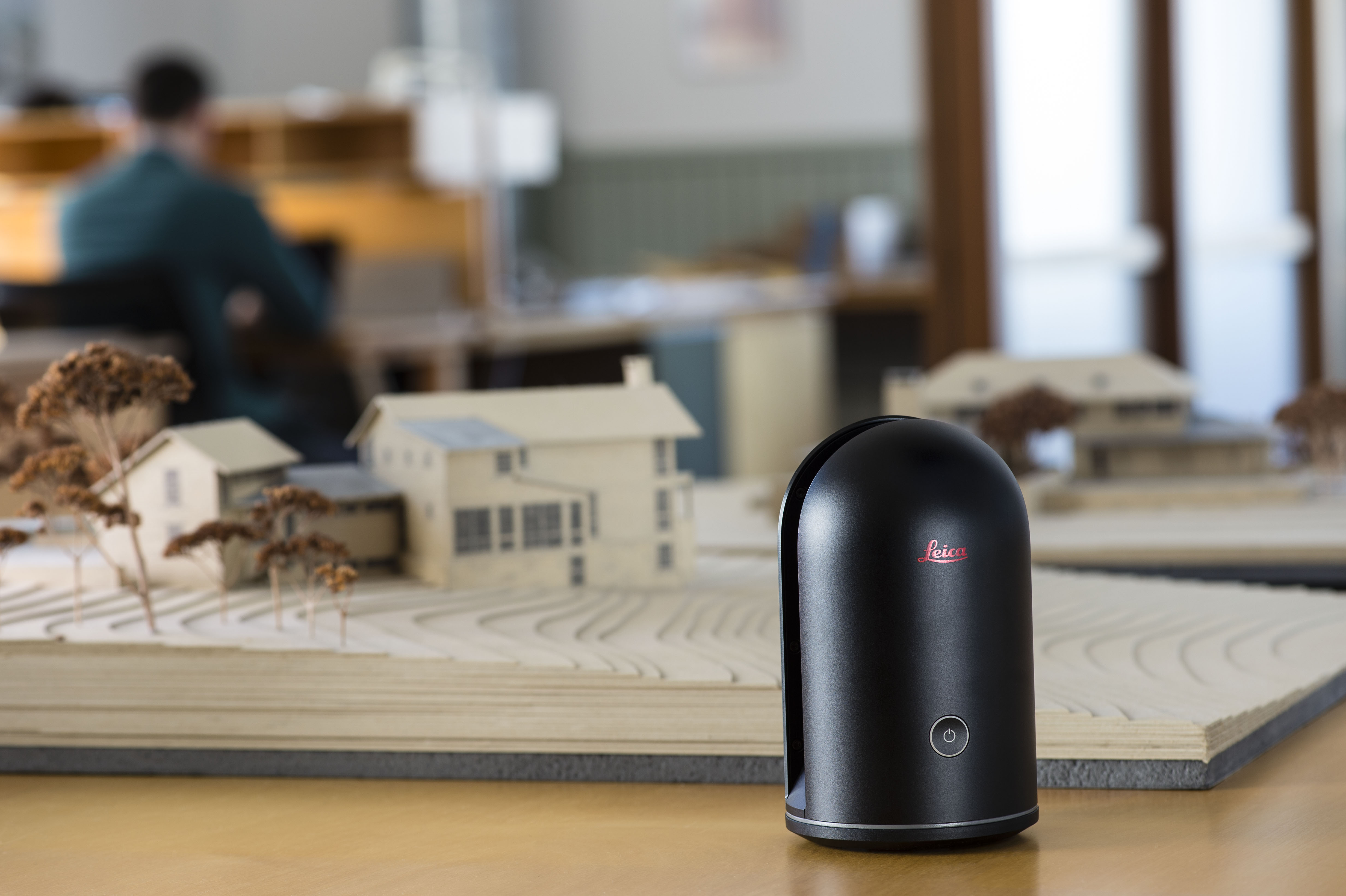
In 2016, the fruit of that challenge arrived. The portable BLK360—small enough to fit in a backpack, easy to pack in carry-on luggage—was the first product in the new BLK line, an imaging laser scanner that delivers full-color panoramic images and a high-accuracy point cloud captured, all with a push of a button.
“When we launched the BLK360 at Autodesk University, there were people three or four deep trying to get their hands on the thing and take their pictures with it,” Hugh said. “I’m walking with my colleagues, and I said to them, ‘You know, I've been working here more than 25 years. Moments like this, where people are so excited about something new, that fundamentally changes the way they're going to work – this doesn't happen very often.’”
The BLK360 took many by surprise for its size, speed, and ease of use. Until 2016, no one was producing terrestrial scanners that could fit in your hand and with the accuracy that the BLK360 delivers. And no one was making them as easy to use as the BLK360, which democratized the use of reality capture worldwide with so many new applications and uses.
"People were doing so many new things with it, turning it upside down, lowering it down maintenance holes, scanning sewer lines and drainage lines underneath cities. People were even using it to scan the interiors of cars, or even to do to VFX for films," Hugh continued. "Before, you would never think of using a laser scanner to do these things because they were just so big, bulky, expensive, and difficult to operate. Because of the BLK360's small size and weight, they thought ‘I can use this in a lot of new ways.’"
Customers React
Customers took note.
“I came across the Leica stand [at a digital construction fair] and it was easy to identify that this would be a good addition to our digital construction tools,” said Paul McGeachy, Design Manager with Gilbert-Ash, an award-winning UK construction firm that's completed high-profile and prestigious projects ranging from hotels and offices to foreign embassies and consulates.
At the time, Gilbert-Ash was designing plans for the Diplomatic Teaching Academy in the Foreign & Commonwealth Office in London. The structure’s site was in the confines of a courtyard at the UK Foreign & Commonwealth Office in London—a historic building that had to be protected from any construction damage, especially in tight quarters. So everything had to be built off-site and then lifted by crane into the courtyard.
It was a sensitive space that required a delicate touch along with the challenge of completing an intricate and highly modern building with very strict geometrical design specifications.
Using digital construction methods with extremely precise measurements became a must. And for this job, the Leica BLK360 was a perfect fit. McGeachy highlights how the BLK360 transformed the way the firm completes its projects.
“For us to set-out dimensions on site, the only way we could see to do that was to capture it in 3D,” McGeachy explained. “We’re one of the first people in Northern Ireland to invest in the Leica BLK360 [and] with the 3D models we had developed, we could easily identify clashes between disciplines and hold workshops with sub-contractors to develop methods for changes to the design.”
"Design clashes can now be identified earlier, and the client can get a better sense of what they're getting earlier on," he added.
Beyond the BIM
Construction and architecture industries are natural fits for Leica BLK products, but the devices also find broad appeal in other sectors, including historic preservation, facility management, restoration and real estate, engineering, and media and entertainment.
Allan McKay, a VFX producer in Hollywood who has worked on films including Avengers: Endgame, Flight, and Star Trek: Into Darkness, as well as video games like Destiny, Call of Duty, and The Division, says the BLK360 has streamlined his process and helped maximize his efficiency.
"When producing [a visual] asset moving through a real-world environment, you must align everything digitally to that real-world environment,” he said. "Now, with the BLK360, you can simply survey the environment and use the data to accurately insert your VFX asset or whatever other asset you create."
There’s also enormous power in "having all the information that you capture on the day of the shoot, even data from a moment of one shot," he said, making for much faster production.
Going Extra-Terrestrial
The BLK360 represented an impressive innovation in tripod-mounted laser scanning. Yet Leica Geosystems’ engineers and designers were determined to press forward into a new frontier of laser scanning, reimagining what's possible for the technology.
The BLK360 set the groundwork for the rest of the Leica BLK line of products. These includes the BLK247 smart 3D surveillance system, which continuously monitors areas with laser scanning, video, and thermal imaging technology, as well as the BLK3D, a handheld device that uses stereo cameras and photogrammetry to measure an object or structure in 3D by taking a picture.
Jim McMahon, President of Structural Stone Concepts who specializes in historic stone façade preservation in New York City, says the BLK3D is his 'go-to' tool. McMahon works with the New York Historic Preservation Office to replace limestone and granite façades on historic schools and other buildings throughout the city.
For Jim, the BLK3D is more than a durable tool.
"Any building project in any borough [in New York City] should have a BLK3D on-site," he said. “I trust it on-site as I'm working on ladders and scaffolds in tight spaces,” he said. “It keeps up with the hard work we do."
Redefining Mobility
Where the BLK360 changed tripod-mounting scanning, Leica Geosystems engineers took the concept of lightweight, mobile laser scanning to the next level with the BLK2GO, a handheld imaging laser scanner that scans while you walk.

GrandSLAM technology within the BLK2GO tracks itself through 3D environments and rapidly captures 3D point clouds. Nick De Pace, Architect and Professor at Rhode Island School of Design, says that while exploring underground water sources of Naples, Italy, "navigating narrow spaces or the multiple turns in and around more complex sites wasn't an issue. Using the BLK2GO, we scanned wherever we walked."
With the BLK2GO's speed and low-profile design, Nick said he and the team "carried it in a backpack during our travels from one site to another. It was all very convenient. And if we missed something, we'd quickly retrace our trek and capture again."
The BLK2GO also shines in the engineering industry. At BOM Engineering, the BLK2GO's speed significantly reduced the company's time on-site, and clients could better experience what the project would look like through digital reality.
"With the BLK2GO, we scan industrial areas in need of renovations – either enlarging spaces or reconstructing them for production,” said Kim van Hoeve of BOM. “Within a matter of hours, the BLK2GO scans an area, produces a point cloud, and then we render it through software in VR. Our clients can then walk through the space seeing the implemented designs."
Visions of an Autonomous Future
The BLK2GO took the tripod out of the scanning equation. The next challenge became: can we remove human intervention and achieve autonomous scanning?
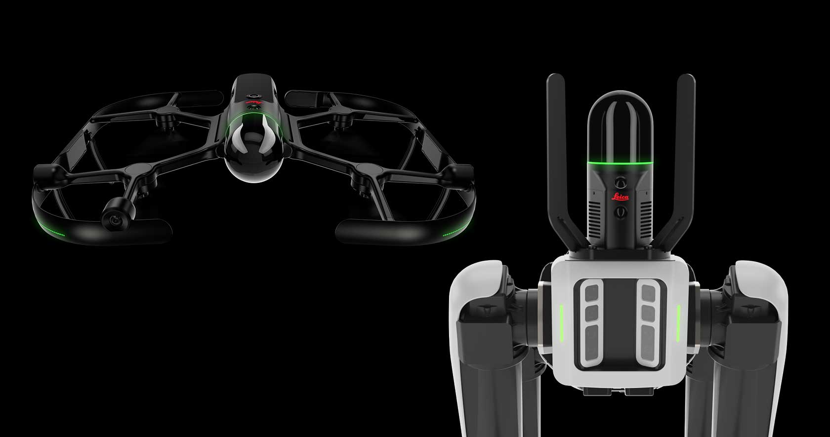
Enter the BLK ARC and BLK2FLY. The former is an autonomous laser scanning module designed for robots, and the latter is the world's first fully integrated autonomous flying laser scanner.
The BLK ARC can be integrated with a robotic carrier to enable fully autonomous laser scanning and can scan hazardous and inaccessible areas to humans, also performing repeat scan tasks autonomously.
The BLK2FLY, on the other hand, captures point clouds of buildings, facades, rooftops, and other inaccessible areas from the air—all with one-button operation and a few taps on a tablet.
Beyond the construction site, the BLK ARC and BLK2FLY have found homes in niches as unlikely as historical preservation and mobile monitoring.
The Archaeological Park of Pompeii in Italy, for instance, uses both the BLK ARC and the BLK2FLY, along with other technology, to help manage the Pompeii site and increase worker safety while scanning existing areas and those undergoing restoration.
The BLK ARC, mounted on a Boston Dynamics’ Spot robot, scans and navigates itself through the ruins as the BLK2FLY captures the site from above. With these two autonomous devices, park and Italian authorities are monitoring, collecting data, and scanning in a continuous effort to secure Pompeii's preservation from damage by natural elements, relic thieves, and tomb raiders.
“Technological advances in the world of robotics, in the form of artificial intelligence and so-called autonomous systems, have produced solutions and innovations typically associated with the industrial and manufacturing world, but which until now had not found an application within archaeological sites due to environmental conditions and the size of the site,” Pompeii Park Director General Gabriel Zuchtriegel said in a press release.
“Often the safety conditions within the tunnels dug by grave robbers are extremely precarious, as a consequence of which the use of a robot could signify a breakthrough that would allow us to proceed with greater speed and in total safety," he added.
Democratizing Reality Capture
Handheld. Airborne. Robotic. This is the future of Leica BLK, which began with the BLK360 and the goal of making fast, portable, and easy-to-use reality capture accessible to both existing industries and people who’d never encountered 3D scanning before.
That ethos continued as the series grew to include the BLK247, BLK3D, BLK2GO, BLK2FLY, and BLK ARC – all pillars of accessibility and autonomy both in mechanical form and the software that goes with it
It's not all about what's in the box, it's what's all around the box as well,” Baertlein said. “And by that explicitly, I mean, the software. The BLK360 launch showed us how important it was to have a really integrated system in terms of a seamless workflow. It opens a lot of doors that are not otherwise available to be opened.”
Between the BLK series’ products high capability, ease of use, portability and autonomy, the future of scanning is wide open – and open to everyone.
“That’s what we mean by democratizing reality capture,” Baertlein said. “It makes ordinary people able to do extraordinary things.”
Ready to see what’s next? Stick with us. New creations and innovations are just around the corner.
Want to learn more? Join us for Hexagon Geosystems’ HxGN Live Global Event June 20-23. Register here.
Disclaimer: This article features the Leica BLK360 G1. Explore the expanded capabilities of the latest BLK360 model here.


