BLK2FLY
Q&A with BLK2FLY Product Manager Pascal Strupler
How do I control the BLK2FLY?
The BLK2FLY is as simple to use as possible and relies on app-based controls. You unfold the device, press the power button, and control everything remotely within the BLK2FLY Live app, which connects through WLAN and LTE. You can plan your projects within the app, and the BLK2FLY will autonomously fly, scan, and complete its mission. You can also get a 2D or 3D view of all that the BLK2FLY captures while in the air and monitor or change the BLK2FLY flight path in real-time. If needed or preferred, you can pilot the device manually using virtual joysticks, an essential safety feature that always keeps you in control.
What features are in the BLK2FLY Live App?
The BLK2FLY Live App monitors flight and data capture and relies on direct touch inputs for you to control the BLK2FLY in the air. Other features include panning around to change viewing direction, pinching to zoom, and double-tapping on live image, all while the BLK2FLY adapts its viewpoint accordingly. You can easily send the BLK2FLY to scan a new area by selecting the area through a point system directly on the 3D view in the app on your tablet. The BLK2FLY will then create its flight path to scan that area quickly and safely.
How do I view what I’ve captured with the BLK2FLY?
The BLK2FLY offers full visual feedback. With the BLK2FLY Live App, you can watch the flight through live panoramic video streamed back from the 5-camera system, or you can get a live 3D view of the environment you’re capturing. Once the scan is complete, data captured from the BLK2FLY can be uploaded to Reality Cloud Studio, powered by HxDR, giving you access to view, share, and store your data, all in the cloud.
How do I set up scan missions for the BLK2FLY?
Select the area directly on the panoramic live view of the desired areas/objects you want to scan, and the BLK2FLY will plan an optimal flight path avoiding any obstacles along the way.
How does the BLK2FLY capture reliable scans while up in the air?
Throughout the scan mission, BLK2FLY will adapt to the object it’s scanning. The BLK2FLY keeps an ideal scanning distance from its objects, allowing for consistent point density, resolution, and fine details within the scan. This enables the BLK2FLY to deliver a uniform clean scan while also eliminating scan shadows. The BLK2FLY also offers a real-time 3D view of the scanned environment, so you can check for completeness and make adjustments while the scan mission is still going.
Do I need certification or specialized training to operate the BLK2FLY?
The BLK2FLY is designed to be simple, safe, and easy to use for anyone, keeping workflows smooth and stress-free. No specialized training is needed, and anyone can operate it with no prior flight experience. However, a UAV pilot license is required, and you will need to consult your local or national flight regulations.
What protects the BLK2FLY from damage on scanning missions?
The BLK2FLY features full spherical obstacle avoidance and autonomous flight path planning powered by our GrandSLAM technology. A fusion of LiDAR SLAM, cameras, GNSS, and additional data from radar modules integrated throughout the BLK2FLY facilitates an easy and safe flight through the sky. The BLK2FLY computes its own flight and scan paths, and integrated GrandSLAM allows for the BLK2FLY to avoid any obstacles on the way and return to the launch point on the shortest path possible. We also included GNSS for absolute data geo-referencing, which identifies the device’s location, then calculates and optimizes the safest, most efficient route to take when scanning, all while maintaining proper distance from the desired scanning subject.
What’s the battery life like for the BLK2FLY while in the air?
The BLK2FLY’s battery, while in the air, runs for approximately 13 minutes. The BLK2FLY has a hot-swap battery system and will propose to initiate a return to home once the battery is low, then continue its scan mission once it has a new battery. Also, if the iPad loses the connection for both WLAN and LTE, BLK2FLY will automatically return to the launch point.
What about aviation requirements?
BLK2FLY supports all regulatory aviation requirements like remote ID in the US and Europe and will inform the operator of local airspace breaches.
How to store/travel with the BLK2FLY?
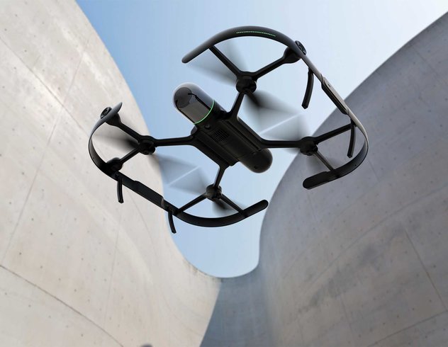
In its simple and foldable form, the BLK2FLY is the smallest flying laser scanner on the market. It only weighs 2.6 kg (5.95 lbs.), and you can easily fold it into a case and fit it in an airplane overhead compartment.
BLK ARC
Q&A with BLK ARC Senior Product Engineer Valentina Albano
What does “ARC” in BLK ARC stand for?
ARC is short for Autonomous Reality Capture. The BLK ARC allows for a new level of autonomy, helping you eliminate extra work and gain efficiency. It removes the need for human intervention when scanning dangerous or hard-to-reach areas, such as site inspections in risky locations like mines or power plant facilities or quick documentation after ecological or environmental disasters. BLK ARC also helps perform frequent on-site checks by repeating the same data capture process over a set time for efficient as-built verification. These are just a few of the possible scenarios and applications for the BLK ARC.
What improvements do I gain on-site with the BLK ARC?
With the BLK ARC laser scanning module, not only can you minimize or remove human intervention but also secure workers’ safety due to remote operation. You can also capture static and mobile scans during the same mission that are automatically registered together and then upload to the Reality Cloud Studio platform—allowing you to instantly view and share the data. You can quickly maximize productivity by reducing on-site time, planning scan missions offline, and automatically uploading scan data to the Reality Cloud Studio. You’ll also optimize repetitive data capture tasks by using the BLK ARC for routine, autonomous scanning of site conditions, such as daily scans or timeline scans.
How does BLK ARC autonomy function?
The BLK ARC module enables autonomous robotic navigation and scanning through our GrandSLAM technology, combining three powerful SLAM methods: LiDAR SLAM, visual SLAM, and an IMU.
With LiDAR SLAM, different surfaces and unique geometry are identified and then analyzed to calculate its 3D position. In Visual SLAM, three panoramic cameras identify similarities between consecutive images to calculate the scanner’s movement through 3D space. And in IMU (Inertial Measurement Unit), movements are sensed to calculate the change of position in 3D space. With the GrandSLAM technology of the BLK ARC, you can rely on the accurate autonomous movement in any area you use it.
How does the BLK ARC use GrandSLAM technology?
The BLK ARC uses Simultaneous Localization and Mapping (SLAM) to position, orient, & navigate itself through 3D space to capture images and dimensionally accurate point clouds in real-time. With GrandSLAM technology, the BLK ARC collects 3D data of whatever area you put it in, identifying on its own through its integrated technology how to maneuver and acquire scans, photos, and measurements.
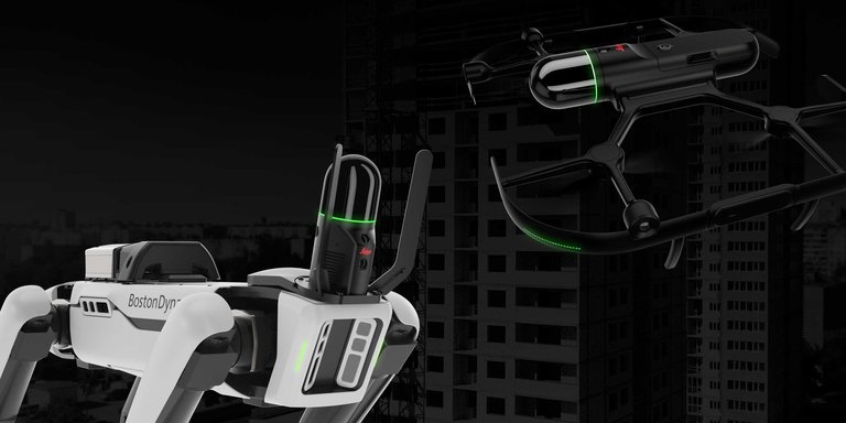
The Boston Dynamics Spot robot uses its close-range perception system to walk through spaces and overcome obstacles on its path. The BLK ARC then applies real-time scanning and GrandSLAM technology to enhance navigational accuracy in more challenging environments.
How do you operate the BLK ARC?
The BLK ARC operates through a browser-based user interface, where you can control robot trajectory and cameras, create user profiles, manage scan settings, and control the robot carrier. You can also perform offline mission planning in Cyclone 3DR remotely and upload those scan missions to the BLK ARC through the UI. Once the mission is complete, BLK ARC UI helps direct the data either into our legacy software, Leica Cyclone, or direct upload from the field to Reality Cloud Studio.
How do I map missions offline?
You can create scan paths for the BLK ARC remotely by using existing drawings, CAD models, or BIM models of a building or area from your computer, wherever you are. The mission can be sent to the robot via an internet connection, which means there’s no need for human intervention while completing its mission. And in case of significant changes on-site, such as construction progress, you can modify and adapt a scan path using the existing BIM model without going back to the field.
How is the BLK ARC “versatile?”
The BLK ARC is a module designed to be used on any robot, and anywhere the robot goes, so do the capabilities of the BLK ARC. As the BLK ARC offers offline mission planning, you can enjoy the flexibility of having the BLK ARC scan on its own and give you the data when you need it. BLK ARC also offers the versatility of capturing two types of scans during the same mission: static scans, which are best for accurate, dense, and crisp point clouds where higher data quality is needed, and mobile scans for faster data collection in larger environments where productivity is key.
How durable is the BLK ARC?
The BLK ARC has protection bars integrated into the mounting plate with a sleek and straightforward design protecting the hardware against physical damage. Be sure to comply with all handling and care instructions to ensure safety.
Will the BLK ARC work on different robots?
Yes. Currently, the BLK ARC is compatible with Boston Dynamics’ Spot robot, but soon the BLK ARC will be compatible with many different robotic platforms and carriers.


