Product Highlights
Bring reality capture to new heights with our autonomous flying laser scanner.
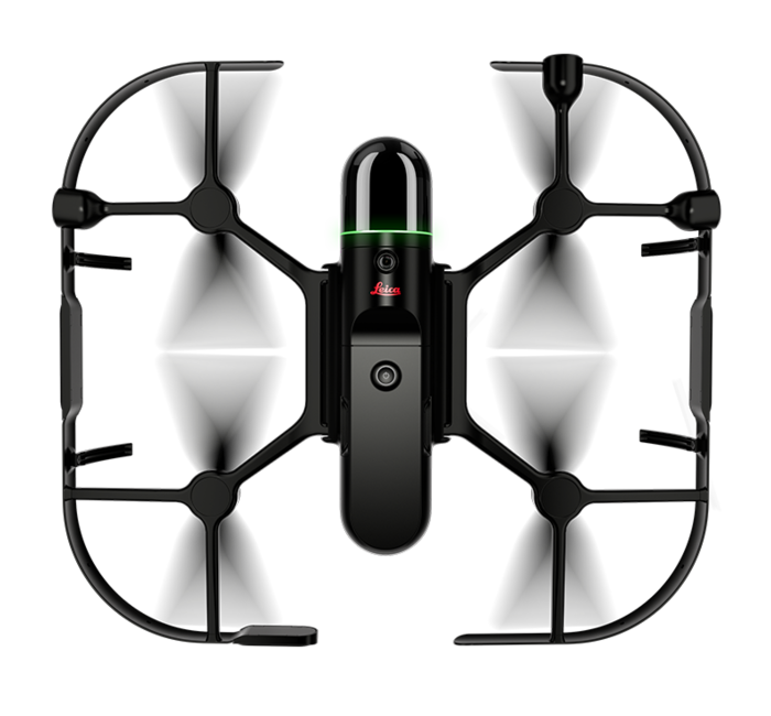
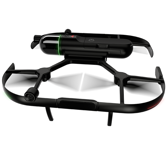
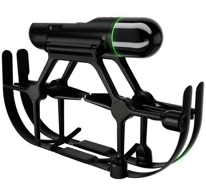
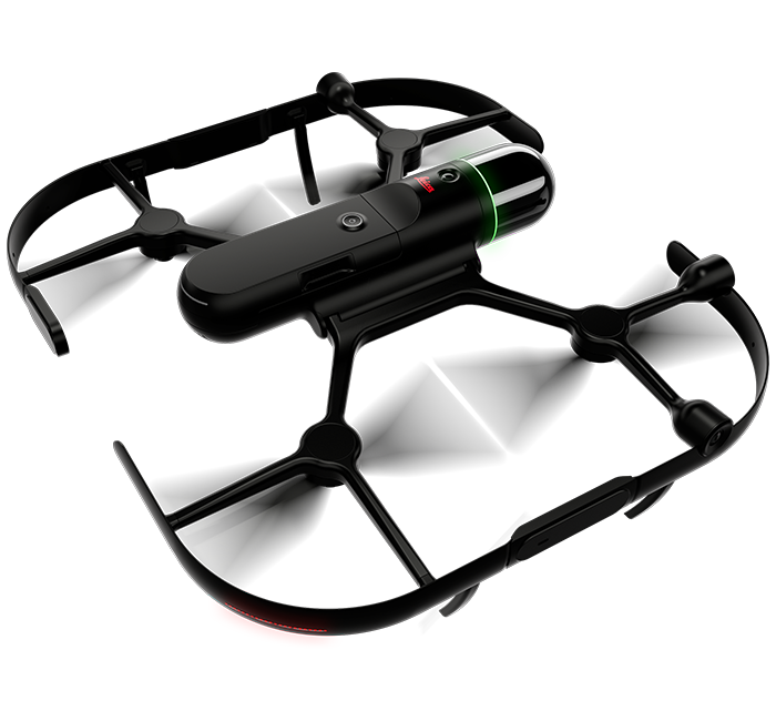
Take your reality capture workflow to the skies with the BLK2FLY, the world’s first fully integrated autonomous flying laser scanner. Capture entire structures, buildings, facades, and other spaces, both indoors and outdoors, all with a few simple taps on a tablet.
With advanced obstacle avoidance and sensor fusion of LiDAR, radar, cameras, and GNSS, the BLK2FLY captures areas you once thought were impossible to scan, bringing immense value to your reality capture data. And you can take complete control at any time via virtual joysticks in the dedicated BLK2FLY Live App.
In The Box:
- Leica BLK2FLY Flying Laser Scanner
- GEB374 BLK2FLY Smart Battery
- GKL352 BLK2FLY Single Battery Charger
- GEV288 USB-C Cable, 1.5m
- Leica BLK2FLY Propellers CW & CCW
- Cleaning Cloth
- Quick Guide
Product Features:

Advanced Obstacle Avoidance
The BLK2FLY uses advanced omnidirectional radar and LiDAR sensors to avoid obstacles, safely capturing accurate and uniform scans.

Autonomous UAV Scanning
The BLK2FLY intelligently identifies the environment around it for its flight plans, keeps the correct distance for ideal scanning, and formulates optimized flight routes.

Indoor Scanning
The BLK2FLY’s indoor scanning mode allows for complete scans of interiors, getting closer to objects, and flying in tight spaces. Combine indoor and outdoor scan data to create a comprehensive model of anything you capture, inside and out.


The BLK2FLY is the easiest and fastest way to scan indoor and outdoor areas that require a UAV. With powerful autonomous technology, the BLK2FLY is easy to use with simplified operation. Unfold the scanner, set it on the ground or floor, fire up your iPad, turn on the BLK2FLY with the push of one button, and you’re ready for takeoff. It is fully compatible with the Leica Geosystems Cyclone suite of Reality Capture software as well as Reality Cloud Studio, powered by HxDR, offers unprecedented scanning agility to reality capture users in industries worldwide.
For a detailed product overview, please visit the Leica BLK2FLY product page.
With a 5-camera vision system and a dual-axis LiDAR scanner that captures 420,000 measurement points per second, the BLK2FLY is ready to take on any project. Fully integrated sensors – radar, LiDAR, cameras, and GNSS – enable advanced obstacle avoidance and heightened spatial awareness to ensure the BLK2FLY always flies safely and takes the most optimal flight path to capture data evenly and quickly. Simply transfer data with USB-C or WLAN connectivity.
Leica Cyclone REGISTER 360 PLUS (BLK Edition) Subscription
Leica Cyclone REGISTER 360 PLUS (BLK Edition) is a simplified version of Leica Geosystems Cyclone REGISTER 360 PLUS that features an intuitive UI, guided workflows and an easy process for sharing data downstream with more advanced tools like JetStream and TruView. Or export your point clouds as a standard E57 file or Autodesk's native RCP file format. Cyclone REGISTER 360 PLUS (BLK Edition) is optimized for the BLK2FLY and provides streamlined workflows to assist new users and speed up the process for experienced users.
Reality Cloud Studio, powered by HxDR
Reality Cloud Studio is Hexagon’s cloud-based application for reality capture data storage, automated meshing and registration, advanced visualization, and up-to-the-minute collaboration. Simply upload your BLK2FLY data directly from the scanner using Reality Cloud Studio’s browser-based UI and work with your data immediately in the field.
Software options for every kind of project
For larger projects or existing Cyclone users, Leica Geosystems Cyclone REGISTER 360 PLUS and Cyclone FIELD 360 are also available to help register your scans together and view scan data and imagery in real-time.
Article number: 938405
BLK2FLY Videos
Scanning an Entire Building with Leica BLK2FLY
Use Cases and Articles
CEPSA Energy Company: Site Expansion | Volterra, Italy: Historic Site Preservation and Architectural Research
Design & Physical |
|
| Housing | Carbon and glass fiber frame |
| Dimension (unfolded) | 53 x 60 x 19 cm |
| Dimensions (folded) | 52 x 32 x 14 cm |
| Weight (incl. battery) | 2.6 kg |
Operation |
|
| Remote control | BLK2FLY Live App for iPad supporting LTE connectivity (iOS 13 or later). Including: flight planning, live 2D and 3D visualization, device status, and data management |
| Communication | LTE Bluetooth® LE |
| WLAN frequencies | 2.4Ghz access point (flight operation), 5 GHz client (data offload operation) |
| Max. / typical transmission distance | WLAN: ~100m, line of sight |
| Internal storage | 256 GB |
| Battery | Li-ion 14.8 V, 6.75 Ah, 99.9 Wh |
LiDAR & Imaging |
|
| Laser class | 1 (in accordance with IEC 60825-1) |
| Wavelength | 830 nm |
| Field of view | 360° (vertical)/270° (horizontal) |
| Scan range | Min. 0.5 m - up to 25 m |
| Point measurement rate | 420,000 pts/sec |
| Vision system | 5-camera system, 1.6 MP, 300° x 180° total, global shutter |
System Performance (SLAM-Based) |
|
| Relative accuracy | <20 mm* |
| Absolute accuracy (w/o GNSS) | 40 mm** |
| Area coverage: Vertical | 1,550 m2 in 12 min. (0.5 pts/cm2) 4,700 m2 in 12 min. (0.17 pts/cm2) |
| Area coverage: Horizontal | 1,350 m2 in 12 min. (0.5 pts/cm2) 4,100 m2 in 12 min. (0.17 pts/cm2) |
Environmental |
|
| Operation temperature | BLK2FLY: +5° to +35° C Smart Battery: +10° to +35° C*** |
| Storage temperature | BLK2FLY: -10° to +60° C Smart Battery: -10° to +45° C |
| IP rating | IP54 |
Data Processing |
|
| Data transfer | Wireless (WLAN & LTE) and USB 3.1 (USB C) |
| Desktop software compatibility | Leica Cyclone REGISTER 360 PLUS Leica Cyclone REGISTER 360 PLUS (BLK EDITION) |
| Cloud solution | Reality Cloud Studio, powered by HxDR: Hexagon Digital Reality (direct upload WLAN & LTE) |
Flight Performance |
|
| Max speed (no obstacle avoidance) | 5 m/s |
| Max speed (obstacle avoidance active) | 3 m/s |
| Max wind resistance | 12 m/s |
| Max flight altitude above sea level | 1,800 m |
| Flight time | 13 min* *400 m above sea level |
Autonomy |
|
| Obstacle avoidance coverage | Full spherical, 360° |
| Obstacle avoidance min. distance | 4 m |
| Collision avoidance: Undetectable objects | Cables <5mm diameter Radar does not reliably detect very thin objects like cardboard or small tree branches. It might miss glossy, transparent or dark surfaces. |
All specifications are subject to change without notice. All accuracy specifications are one sigma unless otherwise noted.
* concrete/brick surface
** 4 m distance from object, 2m/s flying speed, 8 min flight, concrete / brick surface
*** Flight start temperature at +5 °C is allowed, once the temperature of the Smart Battery GEB374 is ≥ 10 °C when flight starts.
Copyright Leica Geosystems AG, Heerbrugg, Switzerland 2021.
Apple and iPhone are trademarks of Apple Inc., registered in the U.S. and other countries. iOS is a trademark or registered trademark of Cisco in the U.S. and other countries and is used under license.